Category: Territory Management
RealZips for Nonprofits: Unlocking Impact with GeoData

Nonprofits face complex geographical challenges that impact operations, donor engagement, and volunteer coordination. With limited resources, they must make data-driven decisions to maximize their impact and serve as many constituents as possible. Without the right tools, it’s challenging to determine where to focus efforts most effectively in their CRM (Constituent Relationship Management).
RealZips empowers nonprofits to overcome geographical challenges, enabling smarter outreach, optimized resource allocation, and deeper community engagement—ultimately helping organizations fulfill their mission more effectively. By enriching Salesforce records such as constituents and households with geographic context, nonprofits gain deeper insights to refine fundraising strategies, enhance engagement, and allocate resources exactly where needed.
This blog explores eight key ways RealZips helps nonprofits streamline operations by automatically organizing constituents—supporters, volunteers, and beneficiaries—by chapters, regions, and service hubs. It also enhances efficiency through workflow automation and equips teams with trusted GeoData for smarter decision-making across these critical use cases:
- Targeted Outreach
- Volunteer Recruitment
- Donors and Fundraising
- Program and Service
- Grant Management
- Event Planning
- Partnership Collaboration
- Crisis Management
Now, let’s explore how RealZips GeoData can empower your entire nonprofit team to overcome geographic challenges and drive greater impact.
8 Ways RealZips Helps Nonprofits Overcome Geographic Challenges
1. Targeted Outreach and Community Engagement
Challenge: Non-profits must identify and connect with the right communities to maximize impact.
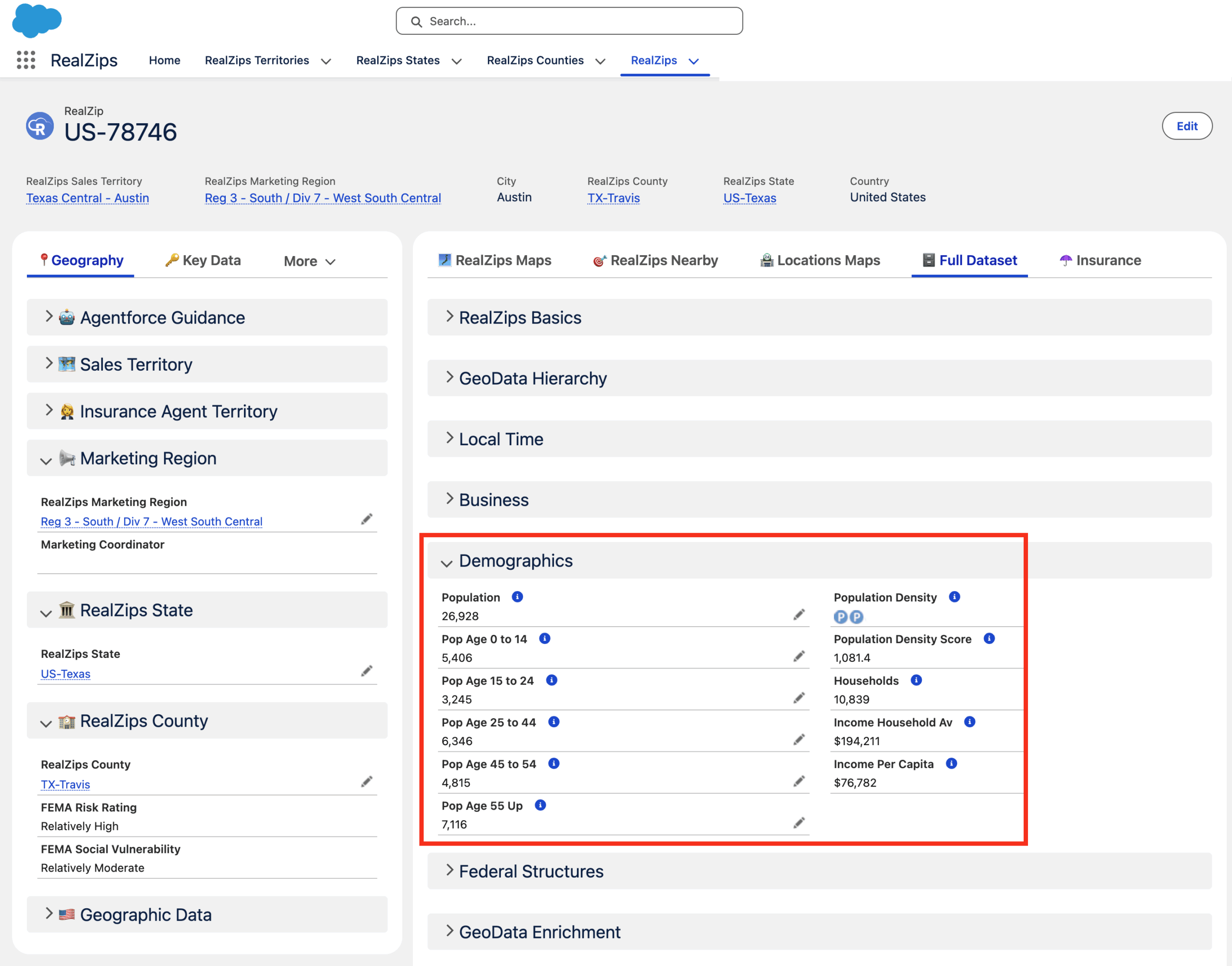
RealZips Solution: Provides detailed local demographic and socioeconomic insights, helping organizations tailor outreach efforts to the right communities.
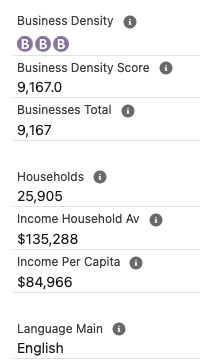
Use Case: RealZips brings Salesforce records to life by layering them with rich demographic insights from sources like the American Community Survey, IRS tax data, FEMA risk assessments, and CDC health metrics. This powerful geographic context enables nonprofits to pinpoint communities in need, make data-driven decisions, and maximize their impact.
2. Volunteer Recruitment and Deployment
Challenge: Effectively placing volunteers where they are needed most can be challenging, leading to inefficiencies, delayed response times, and missed opportunities to provide critical support.
RealZips Solution: Optimizes volunteer assignments based on ZIP code data, travel distance, and community needs.
Use Case: Identify nearby volunteers using a real-time distance search. Generate a ranked list by travel distance to streamline deployment, calculate reimbursements, and encourage volunteers to make the trip and provide their help.
3. Donors and Fundraising Optimization
Challenge: Understanding where donors are located and identifying new fundraising opportunities.
RealZips Solution: Enhances donor segmentation by geography, enabling targeted fundraising campaigns based on giving patterns.
Use Case: Pinpoint donor hotspots by identifying areas with a high concentration of active and potential supporters. Use IRS charitable contributions metrics to benchmark and target ZIP codes with strong giving capacity and strategically plan fundraising events in these high-impact communities.
4. Program and Service Management
Challenge: Determining where to provide programs and services based on community needs and available resources.
RealZips Solution: Provides location-based insights to help non-profits identify underserved areas and allocate resources effectively.
Use Case: Identify communities that would benefit most from your nonprofit’s mission using data from the American Community Survey, CDC, IRS, FEMA, and other trusted sources. Pinpoint and tag ZIP codes where your efforts can drive meaningful, lasting impact.
5. Grant Management and Reporting
Challenge: Many grants require geographic reporting to demonstrate impact in specific regions.
RealZips Solution: Enables accurate tracking of grant-funded initiatives by location, simplifying reporting and compliance.
Use Case: With RealZips, nonprofits can track how grant funds are distributed across different communities. With RealZips, nonprofits can tag each grant-funded initiative down to a ZIP code level, local chapters, and service hubs , ensuring precise reporting on resource allocation. They will generate detailed impact reports, meet compliance requirements, and strengthen future grant applications with data-driven insights.
6. Event Planning and Logistics
Challenge: Organizing events in the right locations to maximize attendance and impact.
RealZips Solution: Helps map out ideal event locations based on supporter density and transportation accessibility.
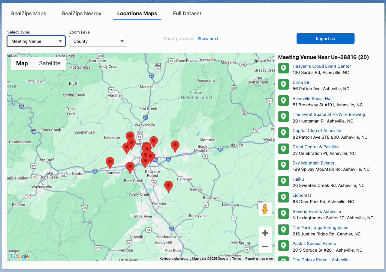
Use Case: Nonprofits hosting fundraising events like galas, concerts, and walkathons can use RealZips to identify ideal locations based on supporter density. They can strategically choose venues to maximize attendance and donations by analyzing high-engagement ZIP codes. Whether for volunteer appreciation, awareness campaigns, or community outreach, RealZips ensures each event drives greater participation and impact.
7. Partnership and Collaboration Strategy
Challenge: Finding and managing partnerships with local businesses, government agencies, and other organizations.
RealZips Solution: Identifies potential partner organizations by region and industry to build stronger community networks.
Use Case: RealZips enables nonprofits to strategically manage partnerships within city, county, and state borders, as well as by proximity to partner locations. Its deep demographic insights help identify critical community needs—such as poverty, health disparities, literacy gaps, internet access, and food insecurity—allowing organizations to form impactful partnerships that drive meaningful change.
8. Crisis Management and Disaster Response
Challenge: Quickly mobilizing resources and coordinating response efforts in affected areas.
RealZips Solution: Facilitates rapid response by efficiently mapping out at-risk areas and directing aid.
Use Case: Nonprofits must act fast when disasters strike—whether wildfires in Los Angeles, severe flooding in Asheville, or hurricanes along the Gulf Coast. RealZips provides geographic insights, combining deep population data with FEMA vulnerability metrics to pinpoint the most affected communities. By flagging high-need ZIP codes in real-time, organizations can swiftly deploy aid, mobilize volunteers, and direct resources where needed. This data-driven approach ensures assistance reaches the right areas faster, improving response times and maximizing relief efforts.
Transform Your Nonprofit’s Impact with GeoData
From improving donor engagement to strengthening community partnerships and ensuring rapid disaster response, RealZips empowers nonprofits to overcome geographical challenges with precision. By integrating location intelligence into Salesforce, organizations can optimize outreach, better allocate resources, and expand services to the areas where they are needed most.
Nonprofits across sectors use RealZips to enhance impact with geographic and demographic insights. From education and healthcare to social services and community development, organizations can better allocate resources, optimize outreach, and engage donors. RealZips streamlines operations for relief efforts, mental health services, and veteran support, improving program delivery, volunteer coordination, and fundraising.
Let’s meet and explore the possibilities
Ready to see how RealZips can help your nonprofit maximize impact? Schedule a personalized demo to discover how geographic insights can enhance outreach, fundraising, volunteer management, and more.
We also offer resources to help nonprofits make the most of their Salesforce investment, including the Salesforce NPSP (Nonprofit Success Pack). Let’s collaborate to expand your reach and bring your mission to more communities.
Book a meeting with the RealZips team:
- Book a demo with the RealZips team: Set up a meeting here
How SalesOps Leverages RealZips in Salesforce
Sales Operations teams are the backbone of efficient sales organizations
They face constant challenges in managing inconsistent customer data, optimizing sales territories, and streamlining Salesforce processes. According to Salesforce, only 35% of sales professionals trust the accuracy of their organization’s data, giving SalesOps teams a tremendous opportunity to improve overall data quality and sales efficiency.
That’s where RealZips comes in. This powerful Salesforce app transforms SalesOps efficiency by cleaning and enriching customer data, optimizing sales territories, and automating sales workflows.
Let’s explore five ways SalesOps teams use RealZips to turn data into revenue:
5 Powerful Ways SalesOps Unlock Sales Success
1. Instantly Enrich Customer data for Smarter Selling
Accurate, enriched data is the foundation of successful sales operations. Without it, teams struggle with bad lead assignments, inaccurate reporting, and inefficient prospecting.
RealZips integrates geographic and market data into Salesforce, empowering sales teams with actionable insights. By enhancing records with location-based intelligence, RealZips ensures:
✅ Consistent, high-quality data across all Salesforce records
✅ Smarter targeting of high-value local markets
✅ Data-driven decision-making for more efficient sales strategies
RealZips automatically adds geographic dimensions (cities, counties, territories) to customer records, while interactive dashboards and drill-down maps give teams deeper visibility into local markets.
2. Unlock Market Insights to Target High-Value Regions
Understanding market dynamics is essential for successful sales strategies. RealZips integrates real-time market data into Salesforce, helping SalesOps teams identify high-potential regions and prioritize sales efforts.
With RealZips, SalesOps teams can:
✅ Analyze market data to refine prospecting strategies
✅ Identify ideal travel zones to empower sales reps
✅ Leverage regional and local insights to strengthen sales pitches
✅ Enhance territory coverage for a competitive edge
With these insights, organizations can execute data-driven go-to-market strategies and unlock untapped revenue opportunities at various geographic levels such as state, territory, county, and by distance:
3. Simplify Territory Management & Maximize Sales Coverage
Sales territories are constantly changing, and managing them manually is challenging—especially for companies with multiple sales channels or growing teams.
RealZips removes the complexity of territory management by allowing SalesOps teams to dynamically define and adjust territories based on trusted and verified market data.
✅ Automatically assign leads and accounts to the right sales reps
✅ Optimize coverage to reduce travel costs and increase efficiency
✅ Ensure strategic territory alignment for maximum revenue potential
Unlike other tools, RealZips maintains sales efficiency by providing a data platform for global countries and regions, county jurisdictions, state lines, and custom-defined marketing and sales regions—giving SalesOps complete control:
4. Automate Sales Processes & Free Up Sales Time
Manual processes slow down sales cycles and create inefficiencies that drain resources. RealZips automates lead assignments, account ownership, and opportunity management, ensuring sales teams always focus on the highest-value prospects.
With RealZips automation, SalesOps teams can:
✅ Eliminate repetitive admin tasks and boost productivity
✅ Speed up lead response times for higher conversion rates
✅ Ensure fair and efficient lead distribution based on market potential
For example, RealZips automatically reassigns leads, accounts, and opportunities based on geographic data—ensuring reps get the right prospects, follow-ups happen fast, and commission payouts will be fair:
5. Align Sales, Marketing & Customer Success Teams
Sales success depends on seamless collaboration across teams. RealZips breaks down silos between sales, marketing, and customer success by providing a single source of truth for geographic customer data.
With RealZips, SalesOps can drive seamless cross-team collaboration in countless ways, including:
✅ Marketing teams can craft hyper-targeted campaigns based on regional insights
✅ Sales leaders can align teams with data-driven territory strategies
✅ Customer success teams can proactively support clients in key markets
RealZips empowers organizations to manage multiple sales territories, marketing regions, and service zones—all from within a single platform, ensuring SalesOps remains in full control. The screenshot below shows how Marketing can instantly manage a Campaign based on distance from a location:
Bringing It All Together
By leveraging RealZips in Salesforce, SalesOps teams gain a powerful toolkit to:
✅ Enhance sales execution with cleaner, enriched data
✅ Unlock new revenue opportunities with market-driven strategies
✅ Automate processes to free up time and boost cross-team efficiency
More and more SalesOps teams are being asked to explore AI and Agentforce capabilities. With RealZips’ trusted geographic data and structured territories, your team can seamlessly integrate AI into Salesforce—in a matter of days.
In summary, RealZips enables SalesOps teams to turn unstructured data into actionable insights, streamline territory management, automate key processes, and foster seamless collaboration—saving time, increasing efficiency, and unlocking new revenue opportunities.
Learn more
- Salesforce Blog: 50 Sales Statistics that Reveal How Great Teams Sell
- RealZips Blog: Why add Geographic Metadata to Salesforce?
- RealZips Blog: Global Territory Management with RealZips
Ready to Unlock SalesOps Success?
Book a custom RealZips demo and discover how your team can manage territories, close more deals, and maximize your Salesforce CRM investment:
Improve your customer data in Salesforce with RealZips

Why should you consider the RealZips app for Salesforce?
The RealZips GeoData Platform structures and organizes your customer data in Salesforce automatically, empowering your team to connect faster with the right customers in the right places.
 Problem: Deterioration of customer data
Organizations are rapidly adding large amounts of customer data to Salesforce. As more data is added, the ability to search and report on customer data deteriorates.
Your customer data is becoming more and more disorganized over time, severely limiting your teams’ ability to run targeted marketing campaigns and focused sales activities. When consistent and structured geographic data is missing across records, your team can no longer use customer data efficiently.
Solution: Organize customer data geographically
The RealZips app provides a mission-critical geographic data structure for your customer data in Salesforce. Every record in Salesforce is automatically related to zip code or international postal code. Each zip code holds a wealth of deep geographic information, which automatically organizes and improves your entire customer database.
Your team will be able to instantly search and report across customers and territories, using endless geographical dimensions such as cities, counties, MSA Metros. Deep contextual data for each Zip code will guide your teams activities to the best possible geographic markets.
Tap into local market conditions with deep data
RealZips provides unlimited contextual market data, related to consumers, businesses, business risk, and other local conditions. You can automatically rank every Zip code based on market potential, and compare against your current sales performance.
Jurisdictions such as states, counties and cities often have a great impact on your ability to market and sell. Once you implement RealZips, your team can automatically categorize prospects based on state-based incentives, local laws and regulations, consumer and political preferences, climate conditions, crime risk and much more.
Implement distance zones for marketing, sales & support
Logistics is a key factor in your team’s ability to succeed, even if your team is working 100% remotely. For example, if a prospect is closer to a competitive location, your team is at an immediate disadvantage.
The RealZips app allows you to automatically organize all records in Salesforce by distance to your own locations and competitive outlets. Every customer record will be given a score based on competitive risk and serviceability. In turn, your team can now optimize marketing, sales and support activities based on distance zones.
Unlock Success: Data-driven territory management in Salesforce
A critical key to success for any organization is territory management; automatically assigning prospects and customers to territories and best-fit team members. Creating territories is a data-driven process, requiring robust geographic data, deep market data and your own sales data.
The RealZips app enables your team to use deep data for each zip code while creating and updating territories. Each Zip code can now be treated as a micro-market, comparing market potential against sales results.
Distance calculations are used to automatically predict your teams ability to serve customers in the Zip code. Every Zip code can be served by multiple territories, efficiently managed by the RealZips app.
Which organizations benefit from RealZips?
Organizations with many records in Salesforce will enjoy instant business value from RealZips. If your Salesforce database is burdened with legacy automation (old workflows, process builders, custom APEX) you will rapidly benefit from RealZips, using out-of-box RealZips automation.
RealZips GeoData is proven to empower organizations across all industries, ranging from non-profits to the financial industry. The more data you are managing in Salesforce, the faster you will achieve business value from RealZips.
Organizations that must focus on geographic areas with the highest sales potential (not having an unlimited marketing and sales budget) are very likely to get in touch with more prospects and close more opportunities shortly after implementing RealZips.
Answer these 8 questions and learn if you need RealZips
If you are getting more than three “Yes” responses, you and your team will benefit from adding RealZips GeoData to your Salesforce customer data:
- Is your Salesforce customer data missing geographic data points?
- Does every customer have critical territory team assignments, and distance to closest team member?
- Can you drill-down into customer data across regions, territories, state, counties and MSA metros, and cities?
- Is lead routing already an issue, with hard-to-manage rules and overlapping automation?
- Are you running out of Salesforce Enterprise Management Hierarchies and Territory Assignment Filters?
- Does your Salesforce Org have complex automation for sharing rules, ownership rules and territories?
- Does your marketing team struggle to run campaigns by metropolitan areas and travel distance to venues?
- Does the sales team miss data on where to focus their sales activities, based on local market potential?
How soon should I expect results from RealZips?
The RealZips app can be up and running rapidly. Oftentimes the customer data can be automatically structured into geographic areas and territories on the first day for implementation.
Depending on your Salesforce ORG’s complexity, the RealZips time to value usually varies between immediate value and up to a few weeks to be fully implemented.
What will the RealZips team bring to the table?
Consider the RealZips team your trusted partner in unlocking your team’s sales success. We have 30+ years of experience from global CRM implementations, across most industries.
5 reasons to add RealZips to your Salesforce ORG
RealZips is a data-driven territory management app for Salesforce. RealZips automatically organizes and enriches global customer data records in Salesforce.
Use cases for RealZips range across all industries. The reasons for implementing RealZips are surprisingly similar across different organizations.
These are five common challenges that RealZips will address, enabling you to deliver a better Salesforce User Experience:
- Data Enrichment
- Territory Management
- Actionable Market Data
- Salesforce Automation
- Customer Focus
RealZips is designed to help your team save time and connect faster with customers. Let’s have a look at how you can solve these 5 challenges by implementing RealZips:
1. Data Enrichment
Lack of data points across your Salesforce records cause endless problems and inefficiencies.
Marketing can not effectively segment leads or run marketing campaigns in best-fit geographic areas. Sales can not automatically assign prospects and customers to the right sales resource. Assignments of Cases are delayed, creating friction with your customers.
The Zip code and Country fields on your Salesforce records are used to automatically relate endless data points from RealZips app.
For example, all customer records can instantly be enriched with data points such as city, county, state, MSA metro, time zone, sales team, closest store, and more.
Data enrichment unlocks new ways for marketing, sales and operations to better serve customers.
These are examples of what you will be able to do with RealZips:
- Add time zones to all records in Salesforce, so your team can time mailers better and schedule outbound calls at the best possible moment.
- Activate County and MSA Metropolitan data points, allowing you to automatically group prospects into manageable sub-territories. Your team can now run perfectly targeted marketing campaigns and sales activities.
- Set up automatic Drive Zones around sales and service team members, organizing customers records by distance. Enable your teams to maximize time with customers.
2. Territory Management
It’s virtually impossible to provide your team with a scalable Territory Management solution, complete with interactive maps, dashboards, and integrated reports.
The standard Salesforce Enterprise Territory Management (ETM) does not support granular territory management on a Zip code level. Most organizations therefore struggle to manage smaller geographic territories, that divide states and cities. Overlapping territories is another major challenge, as territories are stacked on top of different sales teams, service teams and channel partners.
Home-grown workarounds for Territory Management quickly become confusing and impossible to manage. For example, sales teams must oftentimes use multiple dashboards, reports and links to mapping tools to understand the geographic assignment and ownership of customer records. Salesforce Admins are then forced to build a dizzying array of automation for owner assignment and Sharing Rules.
RealZips is designed to deliver a data-driven, reliable and scalable solution for Territory Management.
RealZips provides a platform for territory management, completely integrated with global customer data in Salesforce:
- Out-of-box Territory Dashboards for immediate rollout
- Territory assignment templates for instant territories
- Management of overlapping territories across the world
- Map components for any Salesforce page
- Sales team management and ownership automation
- Rules-based territory teams, displayed on Salesforce pages
3. Actionable Market Data
Market data outside of Salesforce is very important, providing insights for strategic planning of marketing and sales teams. Stand-alone market data can range across demographics, consumer behavior, corporate data, regional incentives, local risk exposure and more. The problem is… it’s outside of Salesforce!
The day you start moving market data metrics into Salesforce – combined with existing customer data – is the day you’re creating a substantial competitive advantage for your team.
Market data provides a framework for where to engage in marketing campaigns and sales activities, once the data is in Salesforce. The RealZips app was designed to blend your own customer data with deep market data.
Samples of Zip codes based demographic datasets, available in the RealDatasets.com store. These datasets can rapidly be uploaded into RealZips and integrated with existing records in Salesforce:
RealZips automatically combines customer data and market data, ranking geographic areas and customers based on local market conditions. For example, all prospective customers can be flagged for local incentives, changes in real estate value, or demand for product and services.
Market data in Salesforce opens up endless possibilities to understand each customer’s local market conditions.
The RealZips app makes it easy to add actionable market data of any type to Salesforce. Here are a just a few examples:
 The market data you choose to add, can immediately be added to existing customers records. Prospects and customers will automatically be ranked based on market conditions, distance to sales and service locations, and much more.
Market data in RealZips sets a framework for automating processes, and allowing your team to make instant decisions across territory design, marketing campaigns, and daily sales activities.
4. Salesforce Automation
Trying to automate business processes in Salesforce with missing and incorrect data is a tremendous challenge.
Most attempts to automate processes will be limited to the quality of your existing data.
The Salesforce Cloud has fantastic capabilities when it comes to automation, especially when using Lightning Flows.
However – without useful data points to use in the automation process and logic – you can not make full use of Salesforce Automation capabilities.
RealZips takes your automation and Lightning Flows to new level :
- Automate assignment of leads by combining territory information, geographic data and market data.
- Configure flexible rules-based sharing of accounts, contacts, opportunities and cases.
- Create assignment logic based on distance zones, applicable to stores, service locations, and sales team members.
- Geographic markers such as County, MSA Metro, Territory and more can be used in your automation logic in virtually unlimited ways to speed up your teams’ workflows.
RealZips provides built-in features for lead routing and ownership assignment, used by large global organizations to keep massive amounts of records assigned to the right team members.
5. Customer Focus
The RealZips app and data was designed to empower your team to focus on the right customers, in the right places, at the right time.
How RealZips unlocks your team’s customer-first focus:
- RealZips GeoData organizes your customer data into a geographic framework.
- RealZips Territories makes it possible to roll out a powerful global assignment of internal resources.
- Market Data provides local market conditions, used to drive marketing, sales and support activities.
Salesforce Automation enriched with RealZips makes it possible to build meaningful workflows that help your team focus on what matters most: Customers.
RealZips App for Global Territory Management in Salesforce

Are you planning to expand your business new markets or even globally? Or do you already have an international footprint? No matter the case, the RealZips app streamlines global territory management across you Salesforce CRM data.
When expanding your business geographically, you likely have three critical questions in mind:
- Are we targeting the right geographic areas?
- Do we utilize the right local resources?
- Are we meeting with the right customers?
A data-driven global territory management app running in your Salesforce organization is a must for addressing these questions. The RealZips app is designed to enable your global sales teams to gain insights and drive success.
The RealZips GeoData Platform is one-of-a-kind Salesforce business process management software, since it’s powered by deep geographic data.
RealZips effectively organizes resources across geographical areas, encourages deep collaboration between multiple sales teams, and help your team focus marketing and sales activities in best-fit geographic areas. So, if you want to become a global leader in your industry, this geo-targeting software is a must-have for business.
RealZips Global: Transform your business with geodata insights
This RealZips Platform offers a dynamic global geodata structure that seamlessly enables enterprise territory management. International businesses with multiple branches and sales teams are seeing major challenges such as increasing local competition, and risk of internal overlaps and more. Such challenges can sometimes make survival harder in the industry because everything becomes dependent on the adaptability and alignment of internal resources with both existing and future customers. With RealZips data-driven and global sales-territory management software, you can mitigate these risks.
A 4-step approach to implementing RealZips and driving sales success
The RealZips GeoData platform primarily makes use of this 4-step approach to help you with strategic territory management:
1. Set a Global Territory Management Structure
The RealZips enterprise territory management app for Salesforce is an innovative and feature-rich tool for global enterprises. Being powered by zip codes, postal codes, partial postal codes, and deep market data, this app delivers global coverage, allowing for dynamic assignment of countries, states, cities, metropolitan areas, provinces, etc. You can plan and execute your marketing and sales efforts, based on the depth of these different geographic areas.
Over time, you can instantly add more granular postal code data all countries in the world. Click here to see learn more about deep postal code data for France and Germany.
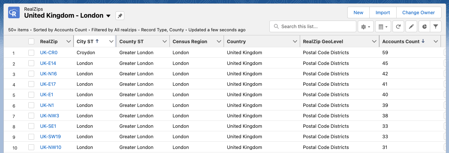
In the example below, the United Kingdom is dynamically divided by partial postal codes. Pay close attention to how the postal codes have different lengths. For example “E1” and “NW10” both represent a single postal code area, effectively managed by the software logic built into the RealZips app:
2. Sales Territory Assignment
Once the geographic structure is in place, the app allows you to proceed with sales territory assignment. The well-designed sales territories, in combination with effective territory management, attract more sales and give you great market coverage. Apart from it, you can offer better services to your customers.
RealZips allows you to:
- Assign complex team structures and overlapping territories across geographic areas.
- Manage your channel partner territories.
- Support growth with the inside sales team and lead assignment
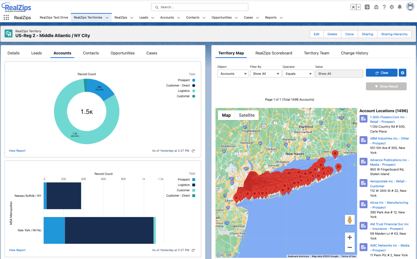
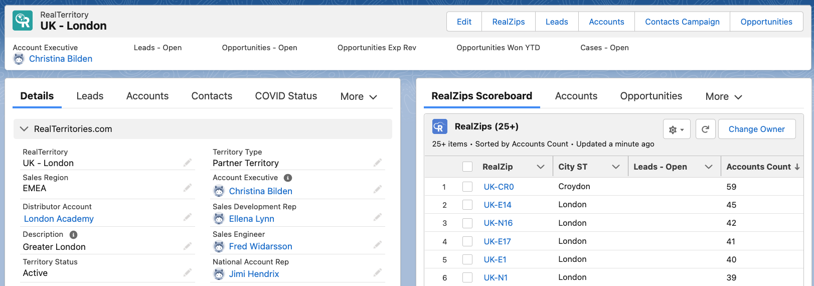
The image below shows the territory for Greater London, complete with team members and a listing of postal codes with the most Accounts in:
3. Align your Salesforce data automatically with Territories
RealZips Salesforce CRM data allows for real-time resource allocation and territory ownership assignment. Your existing Salesforce records will automatically be assigned to a territory.
The RealZips assignment rules, when applied to your Salesforce data becomes is very powerful. You can rest assured that leads are assigned properly, and ownership of customers is always correct. . Each team member can immediately review the team managing a geographic area, and ensure instant collaboration to support each customer.
The lead assignment rules work on the basis of company size and product interest. Therefore, leads are instantly routed to the best-fit resource. In addition, your team will enjoy the RealZips “Nearby’ and Closest’ features, as they get deeper into using the application for daily planning, marketing campaigns, and sales activities.
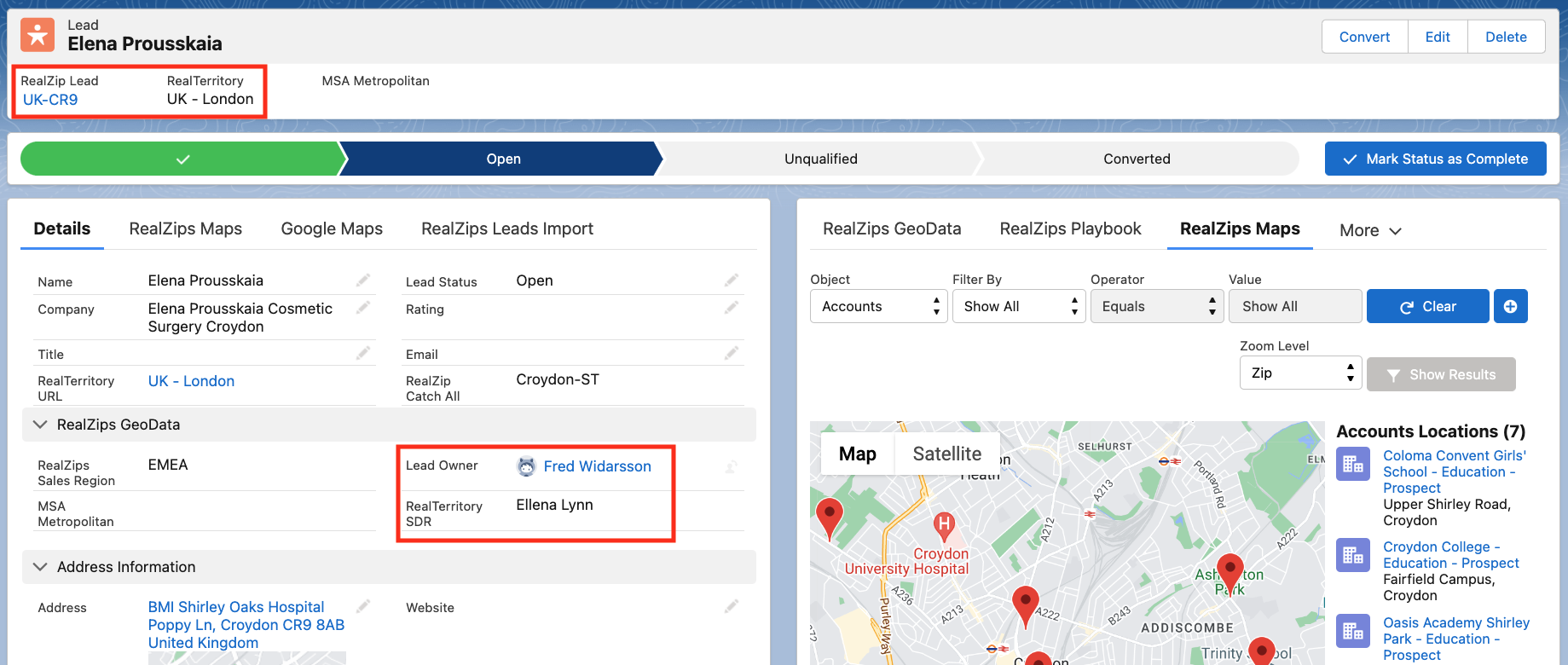
In the image below, you can see lead being automatically assigned to a territory:
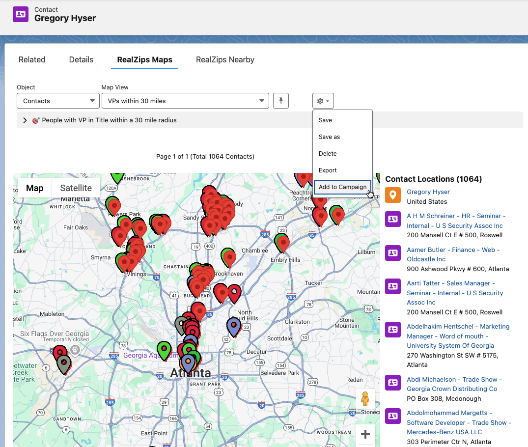
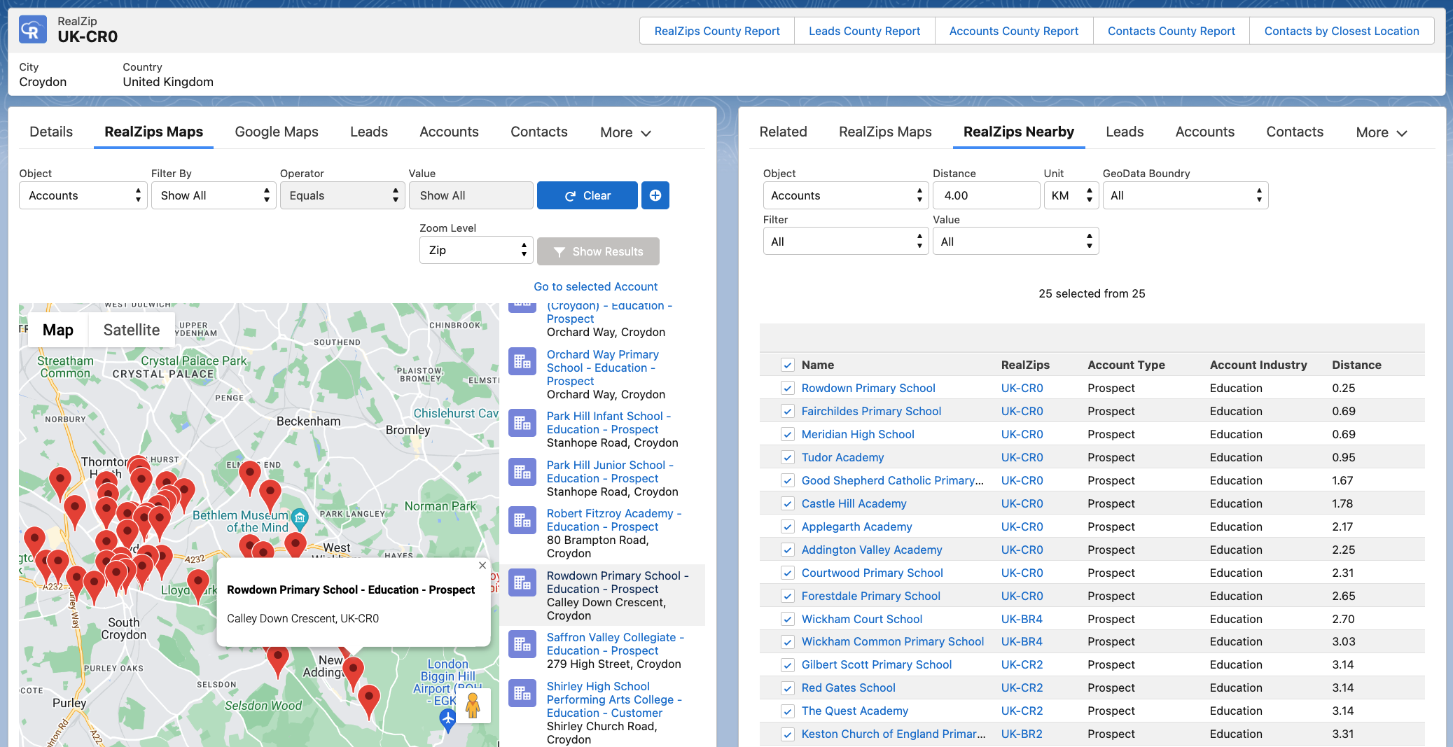
The image below shows the RealZips Nearby feature, used to identify prospects within a selected radius:
- Left side Lighting component: RealZips Maps provides an interactive map of Accounts in the area
- Right side Lightning component: RealZips Nearby let’s you set a radius of e.g. 4 km and drop all records into a Salesforce Campaign
4. Measure Sales Success through Global Territory Reports
Sales metrics play an important role in measuring sales performance and analyzing the success rate of the business. The RealZips GeoData Global territory management software output the global data analytics that help you to easily measure global sales across different marketing channels and campaigns, lead generation, opportunity pipeline, and revenue growth.
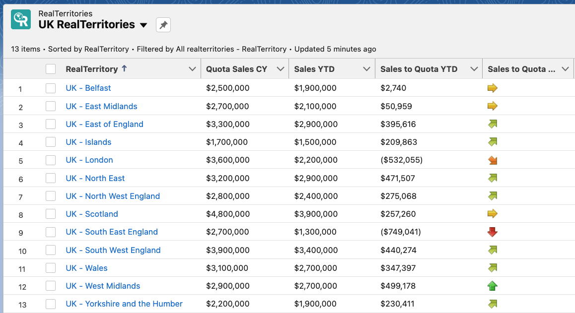
The image below accentuates the performance across sales territories the United Kingdom. It enables the company to quickly allocate resources for optimal growth across any market as well as sales territory:
Discover new opportunities with RealZips GeoData Global Territory Management in your Salesforce
The RealZips GeoData app can help you easily identify new opportunities in the international market and take your company to the next level.
This fully Salesforce-native app has extensive enterprise territory management features and lead assignment rules that help you easily automate business processes, manage global territories for channel partners and internal teams, and analyze sales performance. It further allows you to make better decisions and drive business growth.
To learn more and request a demo, please visit
https://www.realzips.com/products/global-data-management/
RealZips Closest relates Salesforce records by distance
Automatically relate Salesforce records by distance
RealZips Version 12 is now available on the Salesforce AppExchange! The latest version of the RealZips GeoData Platform comes with a new feature named RealZips Closest. This new feature makes it possible for you to automatically relate Salesforce records by distance!
RealZips Knowledge base: How to configure RealZips Closest
What does this mean for your team?
RealZips Closest allows you to calculate distance between key locations and Salesforce records.
By adding distance data to Salesforce, it’s possible to run operations more efficiently. It’s now possible to run highly targeted marketing campaigns, laser-focused sales activities and smooth field service operations!
RealZips Closest can assign leads automatically to the closest resource such as a sales representative, store or channel partner. This article outlines how to use RealZips Closest to improve logistics and create awesome Salesforce automations.
10 min explainer
Scrub timeline to jump across chapters:
Solve major challenges, relating Salesforce records by distance
Common challenges that RealZips Closest can fix
These challenges impact any team’s productivity on a daily basis. RealZips Closest makes possible to eliminate these problems.
1. Logistical challenges
To drive revenue growth, it’s crucial to enable your sales team to operate efficiently. It’s a matter of setting your Salesforce organization in way that helps your team get to the right customer data immediately. By using RealZips Closest for automatic distance relationships across your customer data, you’re empowering your team to make instant decisions. For example, your team will be able to pinpoint all customers within a 5 mile zone from any service location!
RealZips makes it possible to minimize your logistical challenges, as soon as records in Salesforce are automatically related to the closest locations. For example, Leads and opportunities will automatically be related to the closest sales rep, store, service center or a corporate location.
2. Lead routing
We’re sure you’ve noticed how inefficient lead management or lead routing are substantial business challenges, making it harder to sign up new customers. RealZips Closest will allow you to automate and speed up lead management for your team. Thanks to this new feature, it’s extremely easy to automatically assign leads to for example the closest store.
Most companies do not have a strategy for leads and customers located far away from their locations. Before implementing RealZips – they simply assigned customers to a field-based territory – no matter how far away a sales rep, store or service locations might have been! This approach is unfortunately very costly and inefficient. With RealZips Closest, you will be able to solve the problem by automatically assigning customer records to “Out of Market” territories, allowing these customers to be served by efficient virtual teams!
3. Account ownership automation
The next challenge is account ownership. Reliable methods for account ownership automation is absolutely crucial for your team’s success. With theRealZips Closest feature, you can immediately assign prospects and customers to e.g. the closest sales development rep or account executive.
RealZips Closest works with existing zip code-based territories, giving you the best of both worlds. You can set up account ownership assignment to allow the best-fit account executive to engage with the right customer, based on industry, skills, customer stage, distance, and more:
4. Instant distance analytics
RealZips Closest makes it possible to immediately analyze records in Salesforce by distance to critical locations. Closest locations can be sales team members, service team members, store locations, partner offices or airports.
Customer records can be given an automatic “Serviceability Index”. For example, a “best-fit” customer location may need to have a salesperson within 50 miles and a service location within 25 miles.
Your entire customer database can be analyzed by these distance metrics, making it possible to discover geographic areas that your team will be able to serve best. On the flip side, areas that can not be serviced in a cost-efficient and timely manner will automatically be red-flagged.
Powerful use cases for RealZips Closest

Here is a list of popular use cases for RealZips Closest,
that you will be able to configure for your team:
- Automated distance zones around service & sales representatives
and stores. - Assign incoming leads to the nearest store, partner channel,
or sales rep. - Send cases automatically to the nearest service technician or
partner service provider. - Immediately review each lead within at a distance of 15 miles from
an airport your team will travel to. - Divide the entire customer database by distance to the closest
sales rep and meeting venue. - Run marketing campaigns based on distance zones from events
and partner locations.
RealZips Closest:
What makes it possible to automatically relate salesforce records by distance?
After looking at these use cases as well as the challenges solved by RealZips Closest, you must be curious to see how this will work for your team.
RealZips Closest can be used to manage many distance relationships at the same time, making it possible to solve overlapping use cases. You can set up a number of different locations such as competitive outlets, field sales reps, own stores and more.
Here’s an example that will outline how you will be able to help you team succeed:
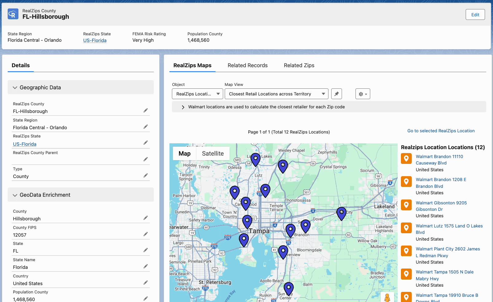
Relate distance data for 172 Apple stores automatically
Your Salesforce Administrator quickly relates all Zip codes with the closest Apple store. Instantly, your entire customer database in Salesforce will be related to the nearest Apple Store!
Display “Closest” locations on each Salesforce record
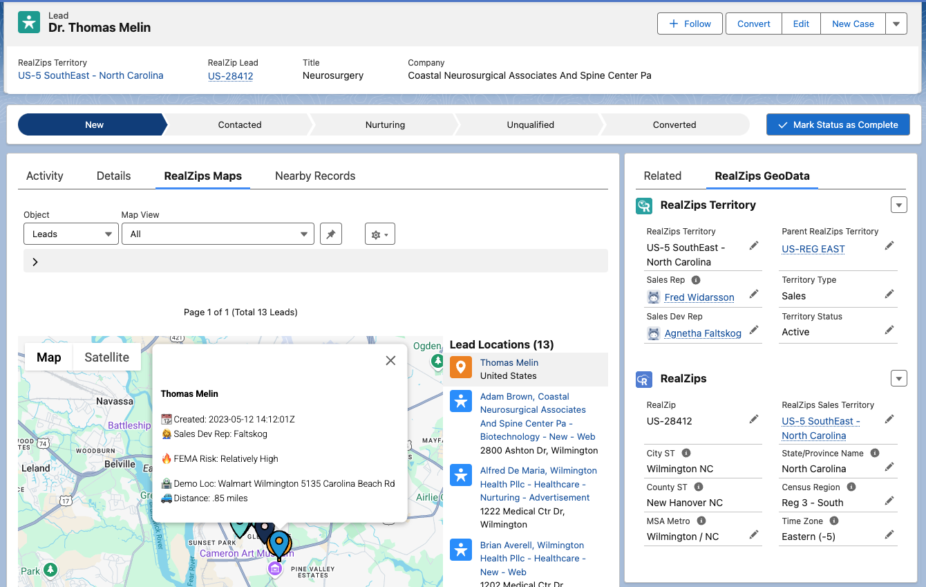
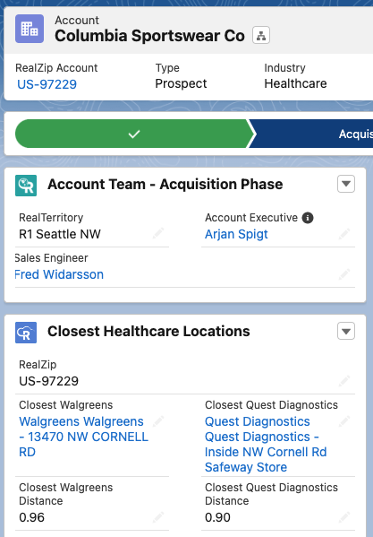
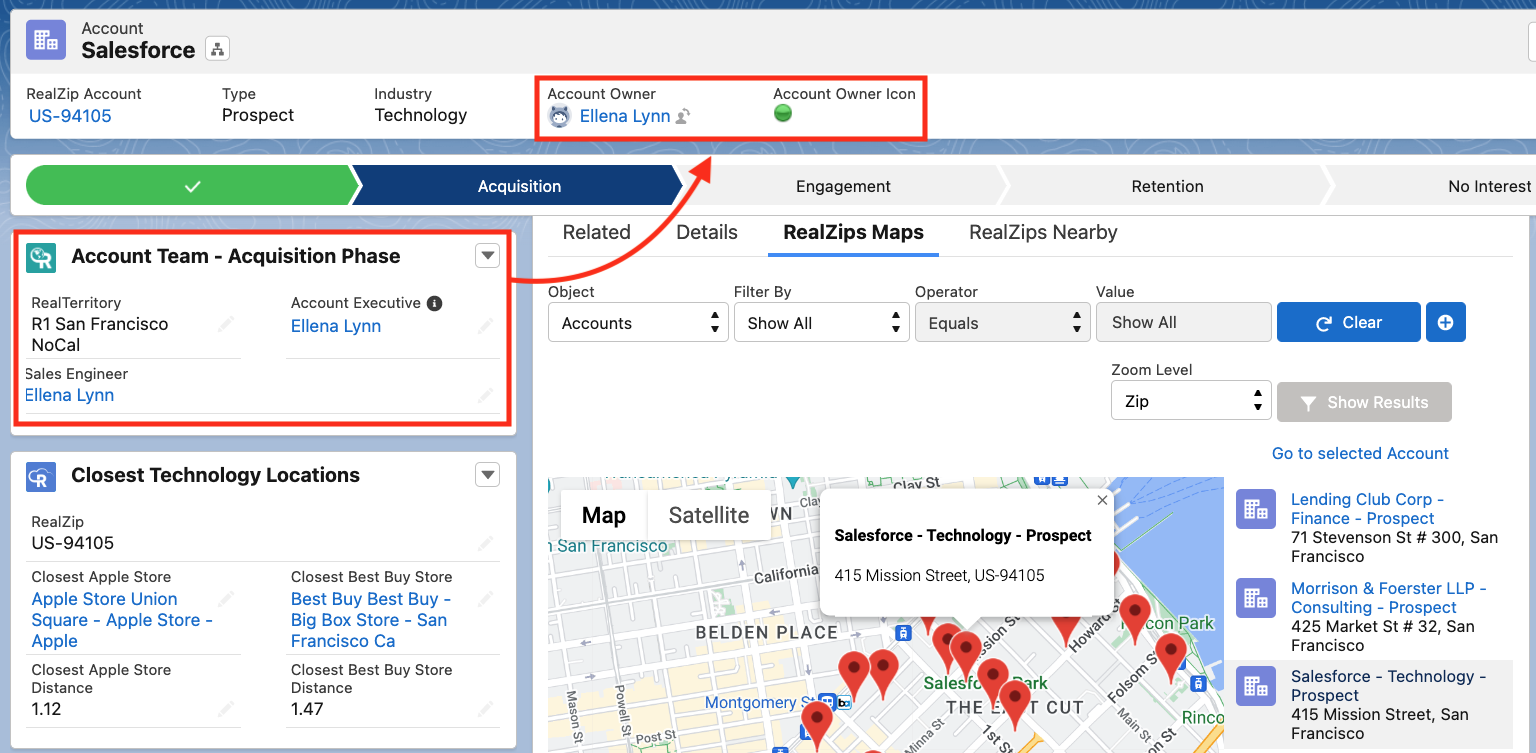
You can show closest locations in many different ways on for example Leads and Accounts. In the example below, the Closest Apple Store to the Account record is displayed. Keep in mind, this relationship between the Account and the Closest Location opens up endless possibilities for automation in your Salesforce Org. For example, you can immediately assign the Account to the closest Sales Engineer!
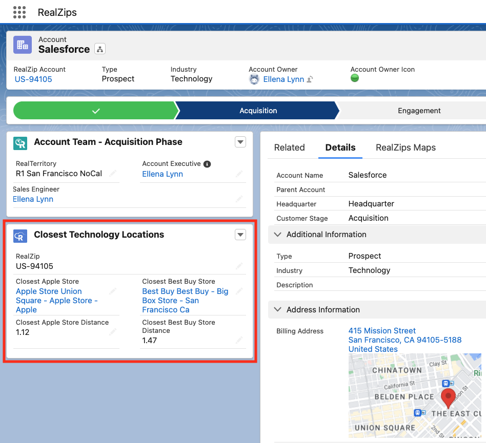
By adding this type of distance data to your existing Salesforce customer data, you will open up fantastic possibilities for your team. RealZips Closest will enhance your own Salesforce data in completely new ways, allowing for connecting faster with customers and removing logistical challenges.
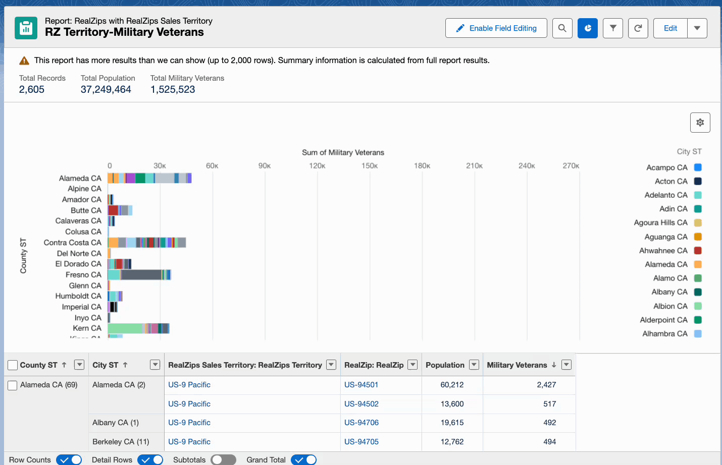
Standard Salesforce reports, showcasing accounts by distance
Reports and analytics in Salesforce is nothing short of fantastic. Now, you can take reporting to the next level by adding RealZips Distance Zones!
You can create unprecedented reports, allowing your team to to analyze the accounts by distance zones to the closest locations.
In the screenshot below, 60,000+ accounts are automatically associated with the closest Apple Store. Notice how the distance zones are highlighted in different colors:
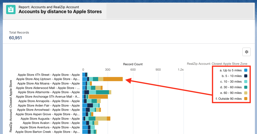
Actionable Salesforce reports
Empowered with these distance zones, your team can approach their customers based on distance. Customers within a 10 mile distance can instantly be invited to the closest store. For customers 30 miles or further away from a store, the goal could be to give them a meaningful online shopping experience.
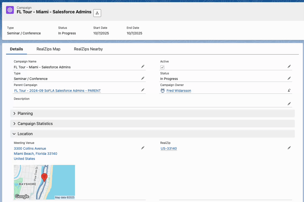
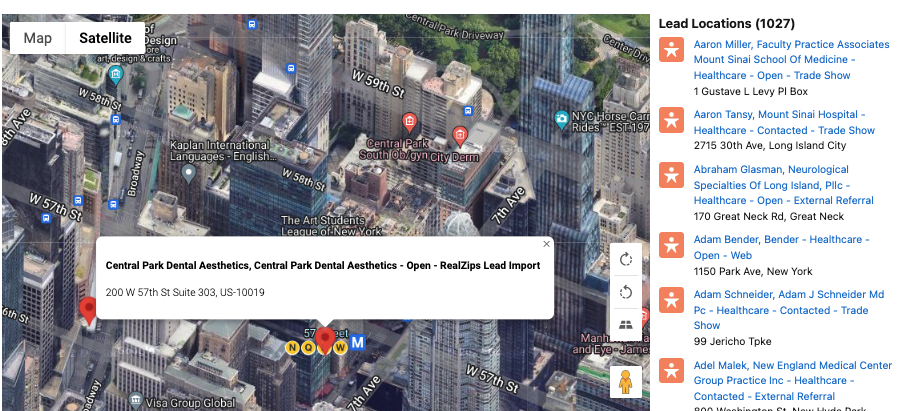
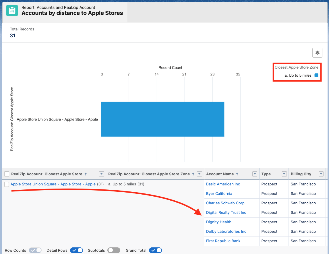
Here’s another example. Your team is co-hosting a pop-up event at the Union Square Apple store. The report below filters out existing customers within 5 miles of the location. Next, run a report on these contacts, add to a Campaign and invite your customers to the upcoming event:
Drive success for marketing, sales and service
Go ahead. Start relating your Salesforce records by distance!
By now, we believe you have many ideas on how RealZips Closest feature will empower your team to market, sell and service in completely new ways. Your team will be able to minimize downtime and focus on areas where they can best serve the most number of customers.
When your are ready to automate business workflows and drive success with RealZips, simply go ahead and Book a Demo with us.
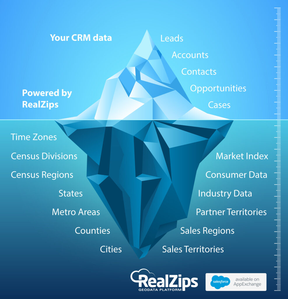
Your CRM data in Salesforce is just the tip of the iceberg
More and more businesses are turning to Salesforce to manage their customer relationships. The payoff is amazing – since organizations can finally get a single view of their customer data – and connect faster with their customers! However, rapid-growth companies are now realizing they need to structure existing CRM data. They go deeper into CRM data – adding a solid foundation of geographic data beneath their existing data to better serve their customers.
How it works
Above the surface, your team is using the standard CRM data every day to close more deals, find more customers, run marketing campaigns, manage opportunities, run customer support and much more.
Unfortunately, all these daily tasks are not supported by a solid data structure that automatically makes it possible to organize and prioritize workflows, such as where to market, which customers to visit first, plus figure out which cities need additional sales and support resources.
How you can solve these challenges and transform your CRM data into a competitive advantage:
- Let the RealZips app automatically structure the CRM data into geographic structures such as time zones, states, metro areas, counties, sales regions, and territories.
- From that moment – your CRM data really comes alive – allowing you to improve search capabilities, reports, and dashboards for your team.
- Add deep market data and run comparisons against customer data. Your team can now discover geographic areas where they will have their greatest growth opportunity.
We’re seeing companies improve marketing and sales strategies with RealZips. They used to put too many resources into geographic areas with too low potential, while leaving areas with high market potential open for their competition.
With the RealZips app in their Salesforce Sales Cloud – these companies are now driving success thanks to fingertip access to geographic data structures and market data previously invisible to their team members.
Why international companies need global territory management

International companies with many sales teams face incredible challenges while trying to earn and retain each customer’s business. As your company’s sales teams grow geographically, the risk for internal overlaps and local competition increase. With RealZips global territory management you will mitigate that risk.
Your organization’s survival depends on its ability to adapt and align internal resources with its current and future customers. These are questions every company looking into geographic expansion – or defending its existing markets – must answer:
- Are we focusing on the right geographic areas?
- Are we utilizing the right local resources?
- Are we meeting with the right customers?
Any company planning to grow or maintain their market share must put a single framework for global territory management in place, allowing their teams to drive sales success by:
- Allocating resources across geographical areas.
- Driving deep collaboration between multiple sales teams.
- Focusing activities in areas with many current and future customers.
Drive global sales success in four steps
1. Set a global geographic structure
We built the RealZips app for powerful territory management around the world. The RealZips app adds geographic metadata, powered by zip codes, postal codes, partial postal codes, plus market data. Your different markets can have varying depths of geographic data to match your marketing and sales efforts.
The RealZips app now delivers global coverage, allowing for dynamic assignment of countries, provinces, states, metropolitan areas, cities, postal codes, etc. In the example below, Japan is divided by our 3-digit postal code level:

2. Assign sales territories
With the geographic structure in place, overlapping territories and complex team structures can effectively be assigned across geographic areas. Future territories can be set up to be deployed at a later date. Channel partner territories can be managed alongside with own channels. Lead assignment and inside sales teams can instantly be assigned to support growth as needed.
The image below shows the territory for Tokyo, complete with the current team members and resources:

3. Align CRM data with territories
Existing records in your Salesforce are automatically assigned to a territory, making it possible to assign ownership and allocating resources in real time.
When territories change and team members are reassigned, ownership of leads, accounts, and opportunities can be made in a matter of minutes. Each team member can immediately reference the team covering the geographic area making instant collaboration around each customer possible.
Leads are instantly routed to the best fit resource based on product interest and company size. In the screenshot below, an incoming lead has been automatically assigned to a territory:

4. Measure sales success
With a powerful geographic geographic structure and territory management solution in Salesforce, companies can now measure global sales across marketing campaigns, lead generation, opportunity pipeline, and revenue growth.
The image below shows performance across sales territories in Japan, sorted by sales to quota. This allows the company to instantly allocate resources for optimal growth across any market and sales territory:

This report is built in the powerful Salesforce Lightning interface, showing 145 sales territories across the world. The report is dynamically updated daily, showing sales progress versus sales quota:

Quick recap
The RealZips app for Salesforce provides a global geographic structure for your team’s customer data. The geographic data makes it possible to plan, deploy, and manage sales territory success.
RealZips is 100% native in your Salesforce. Existing territory management (such as Enterprise Territory Management) can be leveraged in RealZips, along with your existing lead assignment rules.
Business processes can be vastly improved. The RealZips app is used by organizations to drive lead assignment, team collaboration, sales channel management, customer ownership alignment, sales quota, sales analytics, and pinpoint future growth opportunities.
The RealZips app is proven to deliver a rapid return on investment.