Category: GeoData
Why “Valid” ZIP Codes Still Break Your Salesforce Data
Fix Address Quality in your Salesforce data
When it comes to addressing data quality in Salesforce, validation rules are a helpful starting point. They ensure fields like ZIP code, state, and country follow correct formatting, but what happens when the data is formatted correctly, yet still incorrect?
For example, Salesforce can enforce that a U.S. ZIP code follows a 5-digit or 9-digit format (99999 or 99999-9999). But that doesn’t stop a user from entering a completely non-existent ZIP code, or a mismatched city and state.
That’s where RealZips automation steps in.
Format ≠ Accuracy
The Salesforce Validation Rules guide highlights how to enforce correct formatting using functions such as REGEX (regular expression in validation rules and formulas), VLOOKUP (a powerful formula function), and hard-coded lists of country and state codes. These rules ensure structured data entry, which is a critical starting point.
But structure doesn’t equal data accuracy; that is a must for territory assignment, AI processes, and integrations with other applications.
Take these examples:
- A valid-looking ZIP code may not exist.
- A ZIP might be real, but it’s tied to a completely different city or state.
- A two-letter country code could be entered, but it might not align with ISO standards.
These examples may catch and correct formatting issues, but not real-world data accuracy. A ZIP like 99999 might pass validation, but doesn’t exist. Even worse, mismatches like ZIP 85001 + State NY may be saved because both fields look valid, while being completely wrong together.
Without further validation, these inaccuracies can cascade into routing errors, poor segmentation, and broken sales territory logic.
RealZips Solves the Real Problem
RealZips solves this with real-world postal data, not just patterns. Here’s how:
- Looks up postal codes in real-time.
- Confirms whether the ZIP code matches the city, state, and country.
- Blocks or auto-corrects mismatched values.
- Enriches records with city, county, state, region, and territory.
This ensures addresses are right the first time, and is highly useful for automation.
Regex Fails –> RealZips Fixes
Without RealZips: A user types 7097 instead of 07097 for a new lead in Jersey City, New Jersey. The missing leading zero causes Salesforce to accept it as a generic five-digit format. But 7097 isn’t a valid ZIP anywhere, so the system saves a record with no meaningful geographic value. The lead is misrouted, regional reports are thrown off, and manual cleanup is required later.
With RealZips: RealZips instantly flags 7097 as invalid and checks for close matches. It identifies that 07097 is a valid ZIP code in New Jersey, specifically Jersey City. The platform automatically corrects the ZIP, realigns the record with the proper state, and enriches it with city, county, and territory data. The lead is now accurately placed and routed with no manual intervention.
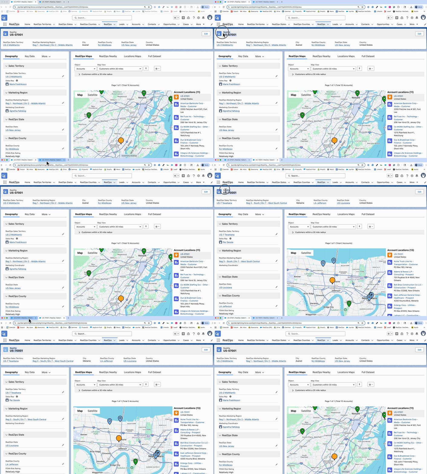
Common ZIP Mistakes (go ahead… check your own data 👀 )
| ZIP Code | Similar ZIP Code | Challenge |
07001 (Avenel, NJ) |
70001 (Metairie, LA) |
Same digits, but different state and region. |
10001 (New York, NY) |
1001 (Agawam, MA) |
001 is a valid 4-digit ZIP in MA (used with leading 0 → 01001). |
30301 (Atlanta, GA) |
33031 (Homestead, FL) |
Close visual match when typed or read quickly. |
85001 (Phoenix, AZ) |
58001 (Arthur, ND) |
Same digits, when transposed, represent different states. |
19104 (Philadelphia, PA) |
19014 (Aston, PA) |
Close regional proximity and digit reversal. |
Can you spot the difference?
3 Ways RealZips Enhances Address Validation
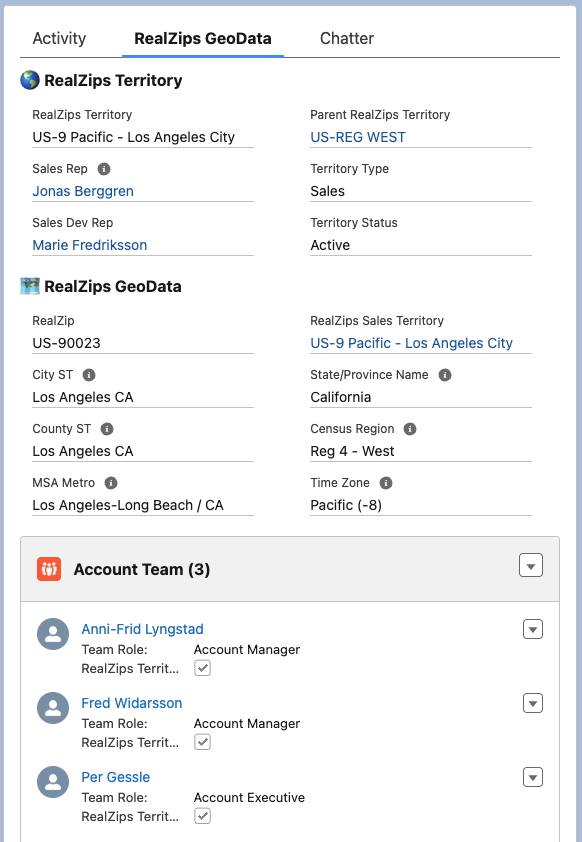
RealZips supercharges Salesforce’s native validation rules by adding a powerful, fully integrated geographic data engine—built natively on the Salesforce platform. Here’s how it transforms address accuracy and automation:
1. Real ZIP Verification ✅
Instead of checking if the ZIP code looks right, RealZips checks if it is right:
- Does the ZIP code exist?
- Is it active and deliverable?
- Does it align with the correct city, state, and country?
All ZIP codes in RealZips are linked to verified metadata: state, city, county, time zone, MSA, CBSA, and more. When users enter a record, RealZips can instantly confirm its accuracy or block it if something is off.
2. Global Accuracy 🌎
RealZips includes ISO-standardized two-letter country codes and validated region or state codes for every supported country, ensuring global address data complies with international standards. This improves system integrations, supports localization efforts, and strengthens compliance.
Beyond simple validation, RealZips automatically enriches records with detailed geographic attributes such as city, county, metro area (MSA), state or province, sales territories, time zones, and more. As a result, every Account, Lead, and Contact becomes geo-complete, enabling seamless automation across Salesforce and connected systems.
3. Automation & Workflow Integration ⚙️
Beyond validation, RealZips can auto-populate fields with standardized geographic info. Use this to:
- Auto-assign leads to territories
- Standardize campaign segmentation
- Ensure compliance with state-based regulatory rules
- Enable AI-powered routing, scoring models, and content generation
Who Benefits?
With RealZips running in the background, every team benefits from cleaner data, smarter automation, and accurate geographic insights built directly into Salesforce. Here are a few examples:
🧑💼 Sales Teams
- Instantly understand each lead’s territory, region, and local rep
- Avoid misrouted opportunities and lost deals
- Enable precision lead scoring based on local market potential
📣 Marketing Operations
- Segment campaigns by metro area, climate zone, or demographics
- Suppress invalid or unserviceable ZIPs from campaigns
- Improve campaign ROI by targeting verified regions
🤖 AI Agents
- Use enriched address data to create smarter prompts and summaries
- Generate insights by true territory, not just raw ZIPs
- Deliver compliance-ready, geographically grounded AI outputs
These enhancements occur in the background, 100% integrated into the Salesforce platform, and are designed to make the agent experience faster and more accurate.
Customer Win: Faster Quotes, Fewer Errors
A leading workplace solutions brand faced a persistent bottleneck: sales reps often worked at high speed in Salesforce to create quotes, but mismatched ZIP codes and states caused downstream integration failures with their ERP system. Each failure required manual cleanup, delaying orders, frustrating reps, and wasting valuable operations time.
To solve this, the team implemented a smart “Quote Preflight Check” powered by RealZips. RealZips provided a verified ZIP-to-state mapping layer directly within Salesforce, enabling automatic validation at the moment of quote creation. If a mismatch was detected, sales reps were prompted to correct the entry before the quote ever left Salesforce.
The results were immediate and measurable:
0️⃣ ERP integration errors dropped to zero for sales rep-created quotes.
⏰ Manual data cleanup was virtually eliminated, saving hours per week across Sales Ops and IT.
⭐️ Salesforce data quality dramatically improved, reinforcing trust across CRM and ERP systems.
By enforcing data integrity at the source—without slowing down the sales process—this company turned a recurring integration pain into a non-issue, accelerating quote-to-order workflows and strengthening system-wide reliability.
RealZips for Nonprofits: Unlocking Impact with GeoData
Nonprofits face complex geographical challenges that impact operations, donor engagement, and volunteer coordination. With limited resources, they must make data-driven decisions to maximize their impact and serve as many constituents as possible. Without the right tools, it’s challenging to determine where to focus efforts most effectively in their CRM (Constituent Relationship Management).
RealZips empowers nonprofits to overcome geographical challenges, enabling smarter outreach, optimized resource allocation, and deeper community engagement—ultimately helping organizations fulfill their mission more effectively. By enriching Salesforce records such as constituents and households with geographic context, nonprofits gain deeper insights to refine fundraising strategies, enhance engagement, and allocate resources exactly where needed.
This blog explores eight key ways RealZips helps nonprofits streamline operations by automatically organizing constituents—supporters, volunteers, and beneficiaries—by chapters, regions, and service hubs. It also enhances efficiency through workflow automation and equips teams with trusted GeoData for smarter decision-making across these critical use cases:
- Targeted Outreach
- Volunteer Recruitment
- Donors and Fundraising
- Program and Service
- Grant Management
- Event Planning
- Partnership Collaboration
- Crisis Management
Now, let’s explore how RealZips GeoData can empower your entire nonprofit team to overcome geographic challenges and drive greater impact.
8 Ways RealZips Helps Nonprofits Overcome Geographic Challenges
1. Targeted Outreach and Community Engagement
Challenge: Non-profits must identify and connect with the right communities to maximize impact.
RealZips Solution: Provides detailed local demographic and socioeconomic insights, helping organizations tailor outreach efforts to the right communities.
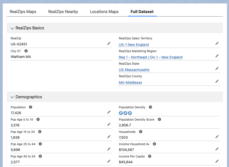
Use Case: RealZips brings Salesforce records to life by layering them with rich demographic insights from sources like the American Community Survey, IRS tax data, FEMA risk assessments, and CDC health metrics. This powerful geographic context enables nonprofits to pinpoint communities in need, make data-driven decisions, and maximize their impact.
2. Volunteer Recruitment and Deployment
Challenge: Effectively placing volunteers where they are needed most can be challenging, leading to inefficiencies, delayed response times, and missed opportunities to provide critical support.
RealZips Solution: Optimizes volunteer assignments based on ZIP code data, travel distance, and community needs.
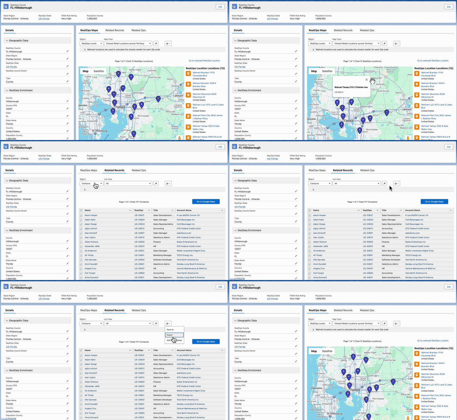
Use Case: Identify nearby volunteers using a real-time distance search. Generate a ranked list by travel distance to streamline deployment, calculate reimbursements, and encourage volunteers to make the trip and provide their help.
3. Donors and Fundraising Optimization
Challenge: Understanding where donors are located and identifying new fundraising opportunities.
RealZips Solution: Enhances donor segmentation by geography, enabling targeted fundraising campaigns based on giving patterns.
Use Case: Pinpoint donor hotspots by identifying areas with a high concentration of active and potential supporters. Use IRS charitable contributions metrics to benchmark and target ZIP codes with strong giving capacity and strategically plan fundraising events in these high-impact communities.
4. Program and Service Management
Challenge: Determining where to provide programs and services based on community needs and available resources.
RealZips Solution: Provides location-based insights to help non-profits identify underserved areas and allocate resources effectively.
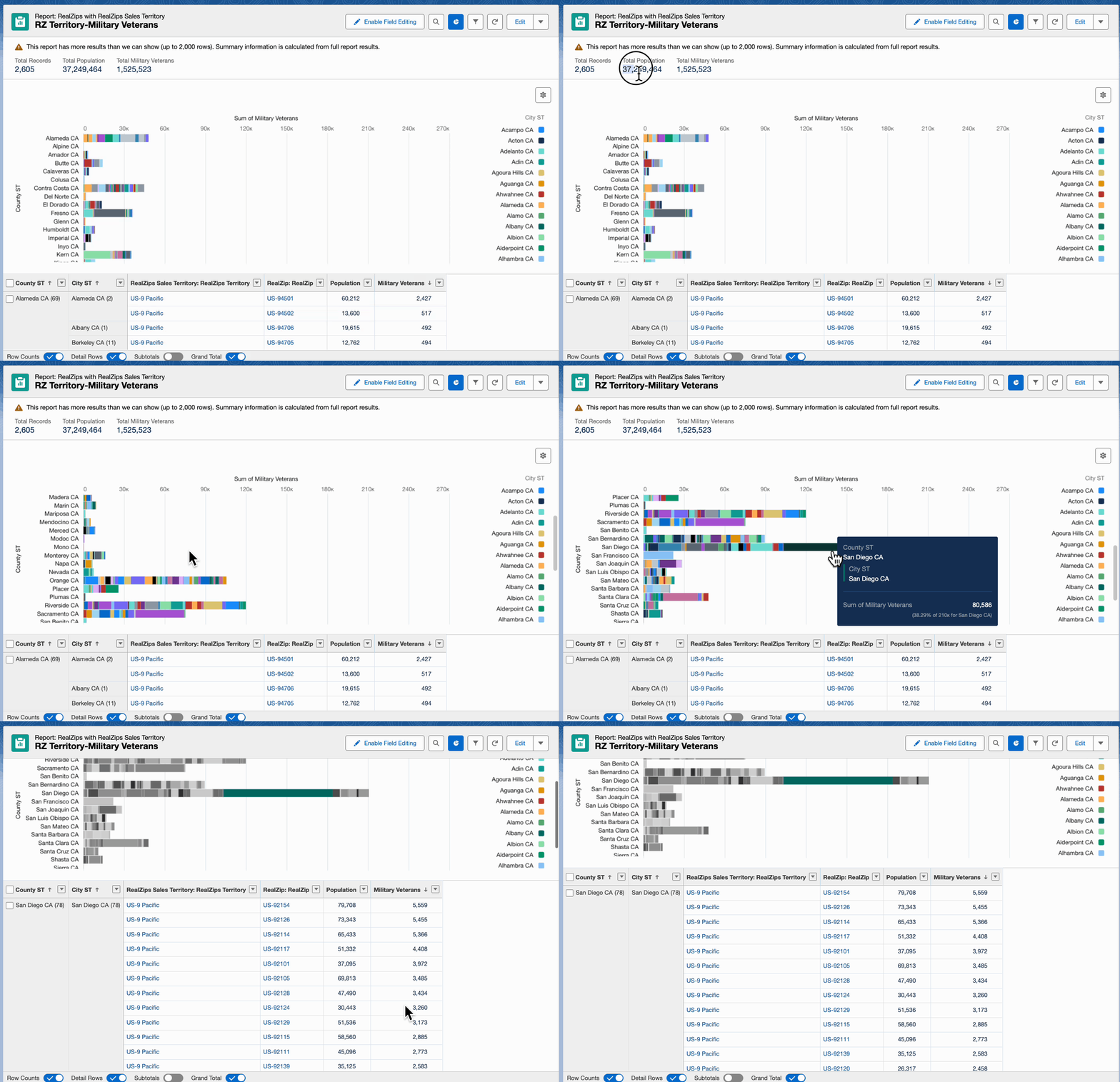
Use Case: Identify communities that would benefit most from your nonprofit’s mission using data from the American Community Survey, CDC, IRS, FEMA, and other trusted sources. Pinpoint and tag ZIP codes where your efforts can drive meaningful, lasting impact.
5. Grant Management and Reporting
Challenge: Many grants require geographic reporting to demonstrate impact in specific regions.
RealZips Solution: Enables accurate tracking of grant-funded initiatives by location, simplifying reporting and compliance.
Use Case: With RealZips, nonprofits can track how grant funds are distributed across different communities. With RealZips, nonprofits can tag each grant-funded initiative down to a ZIP code level, local chapters, and service hubs , ensuring precise reporting on resource allocation. They will generate detailed impact reports, meet compliance requirements, and strengthen future grant applications with data-driven insights.
6. Event Planning and Logistics
Challenge: Organizing events in the right locations to maximize attendance and impact.
RealZips Solution: Helps map out ideal event locations based on supporter density and transportation accessibility.
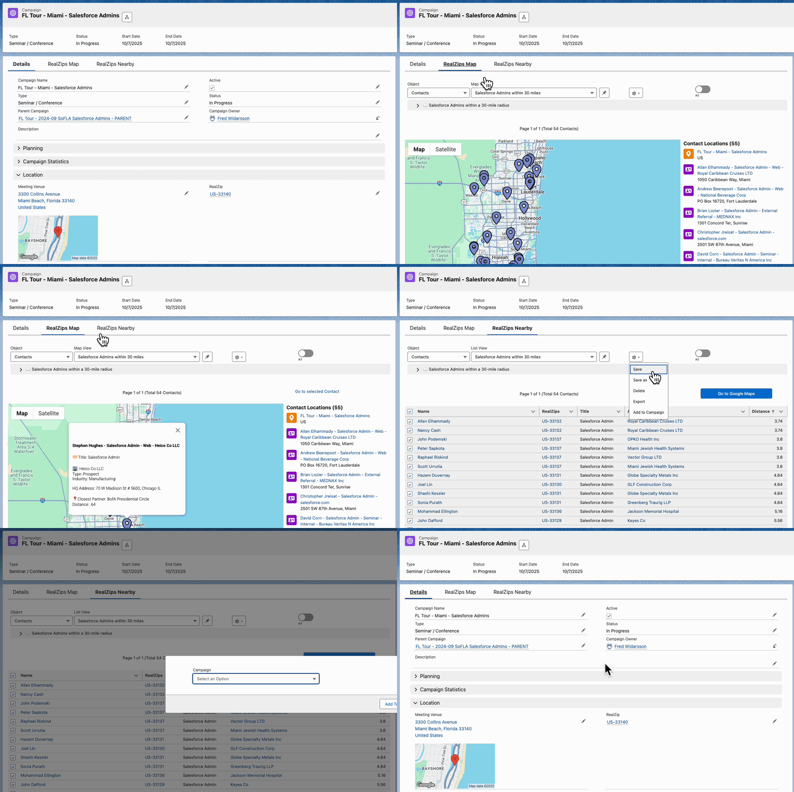
Use Case: Nonprofits hosting fundraising events like galas, concerts, and walkathons can use RealZips to identify ideal locations based on supporter density. They can strategically choose venues to maximize attendance and donations by analyzing high-engagement ZIP codes. Whether for volunteer appreciation, awareness campaigns, or community outreach, RealZips ensures each event drives greater participation and impact.
7. Partnership and Collaboration Strategy
Challenge: Finding and managing partnerships with local businesses, government agencies, and other organizations.
RealZips Solution: Identifies potential partner organizations by region and industry to build stronger community networks.
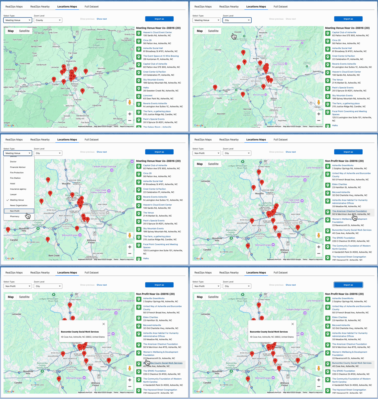
Use Case: RealZips enables nonprofits to strategically manage partnerships within city, county, and state borders, as well as by proximity to partner locations. Its deep demographic insights help identify critical community needs—such as poverty, health disparities, literacy gaps, internet access, and food insecurity—allowing organizations to form impactful partnerships that drive meaningful change.
8. Crisis Management and Disaster Response
Challenge: Quickly mobilizing resources and coordinating response efforts in affected areas.
RealZips Solution: Facilitates rapid response by efficiently mapping out at-risk areas and directing aid.
Use Case: Nonprofits must act fast when disasters strike—whether wildfires in Los Angeles, severe flooding in Asheville, or hurricanes along the Gulf Coast. RealZips provides geographic insights, combining deep population data with FEMA vulnerability metrics to pinpoint the most affected communities. By flagging high-need ZIP codes in real-time, organizations can swiftly deploy aid, mobilize volunteers, and direct resources where needed. This data-driven approach ensures assistance reaches the right areas faster, improving response times and maximizing relief efforts.
Transform Your Nonprofit’s Impact with GeoData
From improving donor engagement to strengthening community partnerships and ensuring rapid disaster response, RealZips empowers nonprofits to overcome geographical challenges with precision. By integrating location intelligence into Salesforce, organizations can optimize outreach, better allocate resources, and expand services to the areas where they are needed most.
Nonprofits across sectors use RealZips to enhance impact with geographic and demographic insights. From education and healthcare to social services and community development, organizations can better allocate resources, optimize outreach, and engage donors. RealZips streamlines operations for relief efforts, mental health services, and veteran support, improving program delivery, volunteer coordination, and fundraising.
Let’s meet and explore the possibilities
Ready to see how RealZips can help your nonprofit maximize impact? Schedule a personalized demo to discover how geographic insights can enhance outreach, fundraising, volunteer management, and more.
We also offer resources to help nonprofits make the most of their Salesforce investment, including the Salesforce NPSP (Nonprofit Success Pack). Let’s collaborate to expand your reach and bring your mission to more communities.
Book a meeting with the RealZips team:
- Book a demo with the RealZips team: Set up a meeting here
How SalesOps Leverages RealZips in Salesforce
Sales Operations teams are the backbone of efficient sales organizations
They face constant challenges in managing inconsistent customer data, optimizing sales territories, and streamlining Salesforce processes. According to Salesforce, only 35% of sales professionals trust the accuracy of their organization’s data, giving SalesOps teams a tremendous opportunity to improve overall data quality and sales efficiency.
That’s where RealZips comes in. This powerful Salesforce app transforms SalesOps efficiency by cleaning and enriching customer data, optimizing sales territories, and automating sales workflows.
Let’s explore five ways SalesOps teams use RealZips to turn data into revenue:
5 Powerful Ways SalesOps Unlock Sales Success
1. Instantly Enrich Customer data for Smarter Selling
Accurate, enriched data is the foundation of successful sales operations. Without it, teams struggle with bad lead assignments, inaccurate reporting, and inefficient prospecting.
RealZips integrates geographic and market data into Salesforce, empowering sales teams with actionable insights. By enhancing records with location-based intelligence, RealZips ensures:
✅ Consistent, high-quality data across all Salesforce records
✅ Smarter targeting of high-value local markets
✅ Data-driven decision-making for more efficient sales strategies
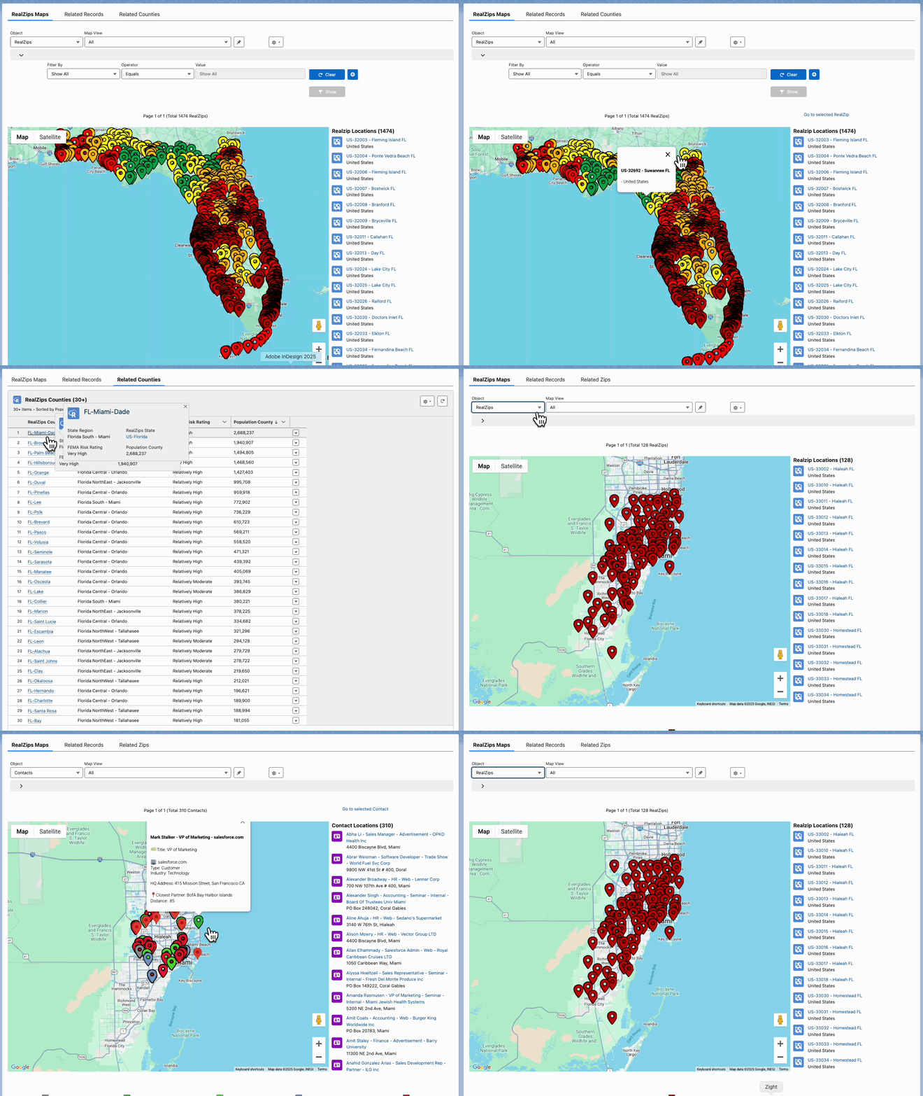
RealZips automatically adds geographic dimensions (cities, counties, territories) to customer records, while interactive dashboards and drill-down maps give teams deeper visibility into local markets.
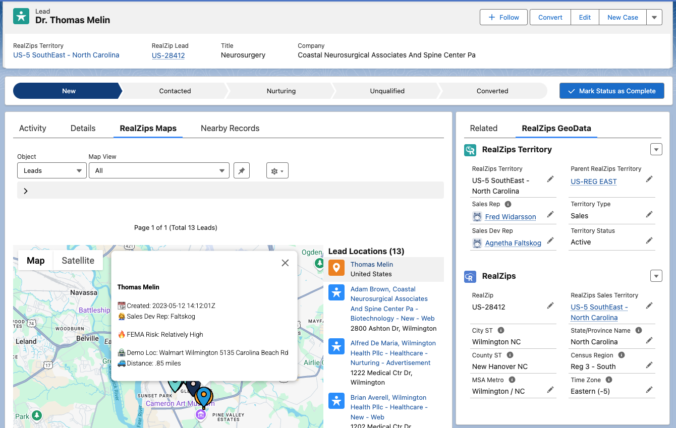
2. Unlock Market Insights to Target High-Value Regions
Understanding market dynamics is essential for successful sales strategies. RealZips integrates real-time market data into Salesforce, helping SalesOps teams identify high-potential regions and prioritize sales efforts.
With RealZips, SalesOps teams can:
✅ Analyze market data to refine prospecting strategies
✅ Identify ideal travel zones to empower sales reps
✅ Leverage regional and local insights to strengthen sales pitches
✅ Enhance territory coverage for a competitive edge
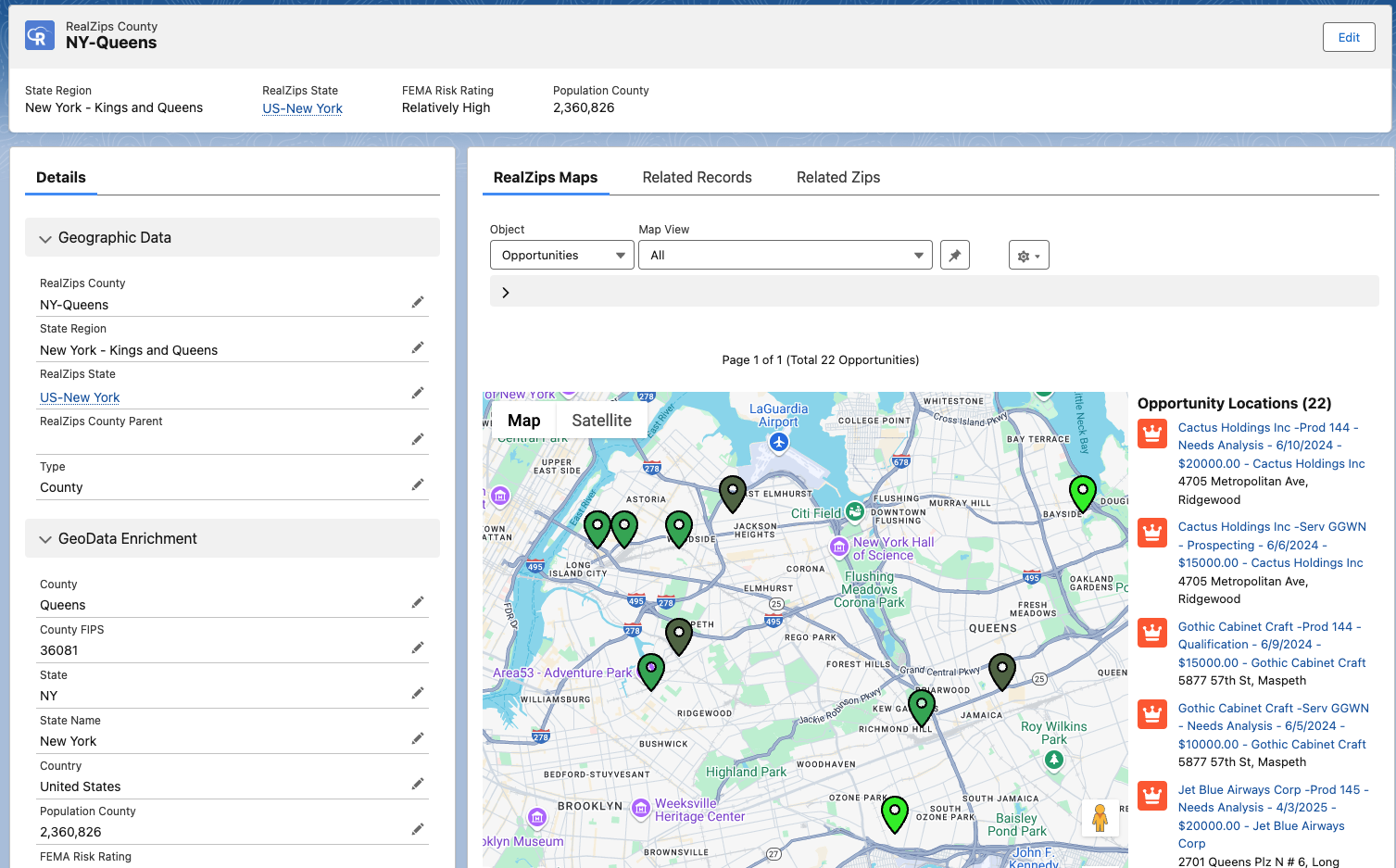
With these insights, organizations can execute data-driven go-to-market strategies and unlock untapped revenue opportunities at various geographic levels such as state, territory, county, and by distance:
3. Simplify Territory Management & Maximize Sales Coverage
Sales territories are constantly changing, and managing them manually is challenging—especially for companies with multiple sales channels or growing teams.
RealZips removes the complexity of territory management by allowing SalesOps teams to dynamically define and adjust territories based on trusted and verified market data.
✅ Automatically assign leads and accounts to the right sales reps
✅ Optimize coverage to reduce travel costs and increase efficiency
✅ Ensure strategic territory alignment for maximum revenue potential
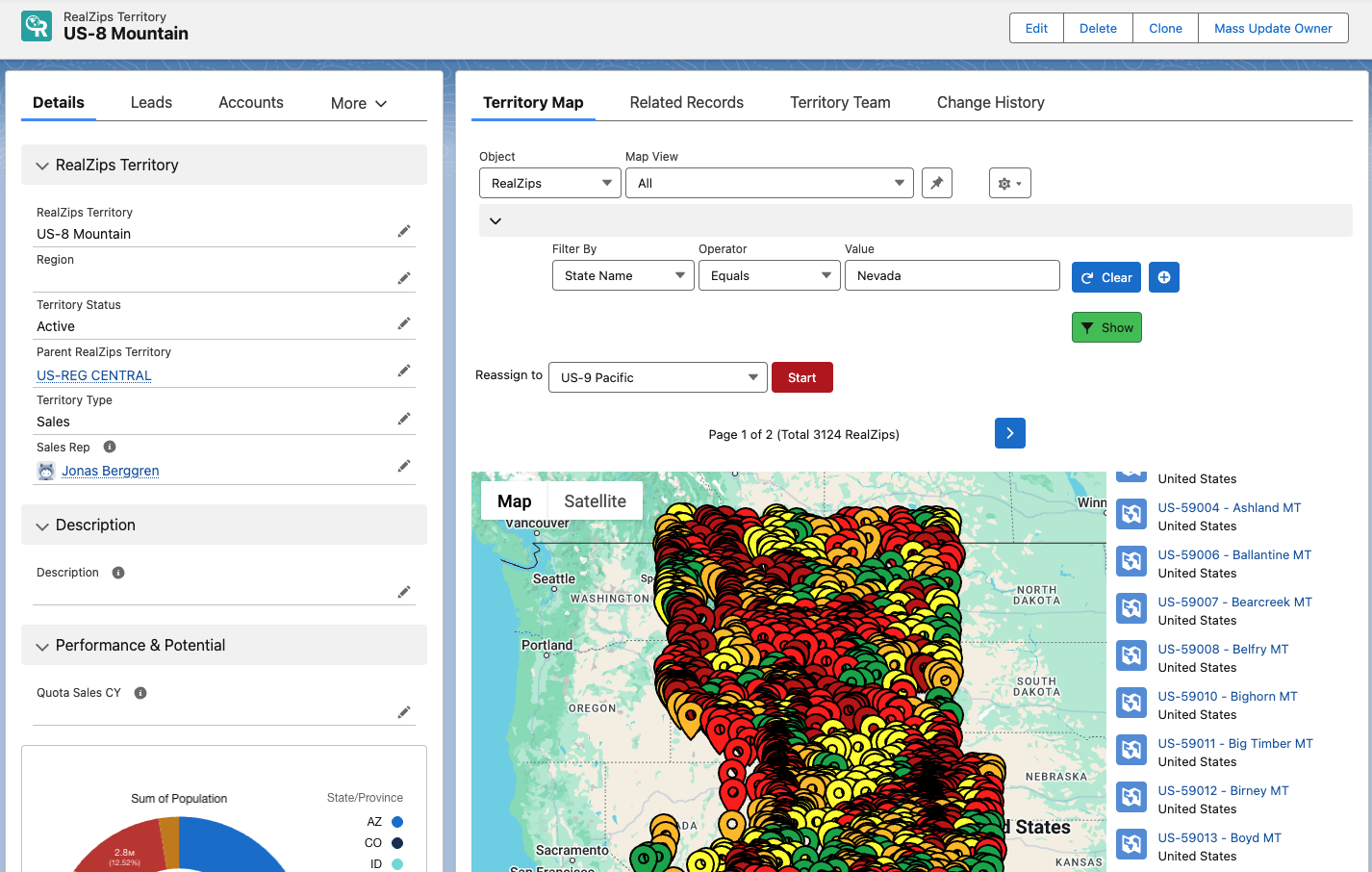
Unlike other tools, RealZips maintains sales efficiency by providing a data platform for global countries and regions, county jurisdictions, state lines, and custom-defined marketing and sales regions—giving SalesOps complete control:
4. Automate Sales Processes & Free Up Sales Time
Manual processes slow down sales cycles and create inefficiencies that drain resources. RealZips automates lead assignments, account ownership, and opportunity management, ensuring sales teams always focus on the highest-value prospects.
With RealZips automation, SalesOps teams can:
✅ Eliminate repetitive admin tasks and boost productivity
✅ Speed up lead response times for higher conversion rates
✅ Ensure fair and efficient lead distribution based on market potential
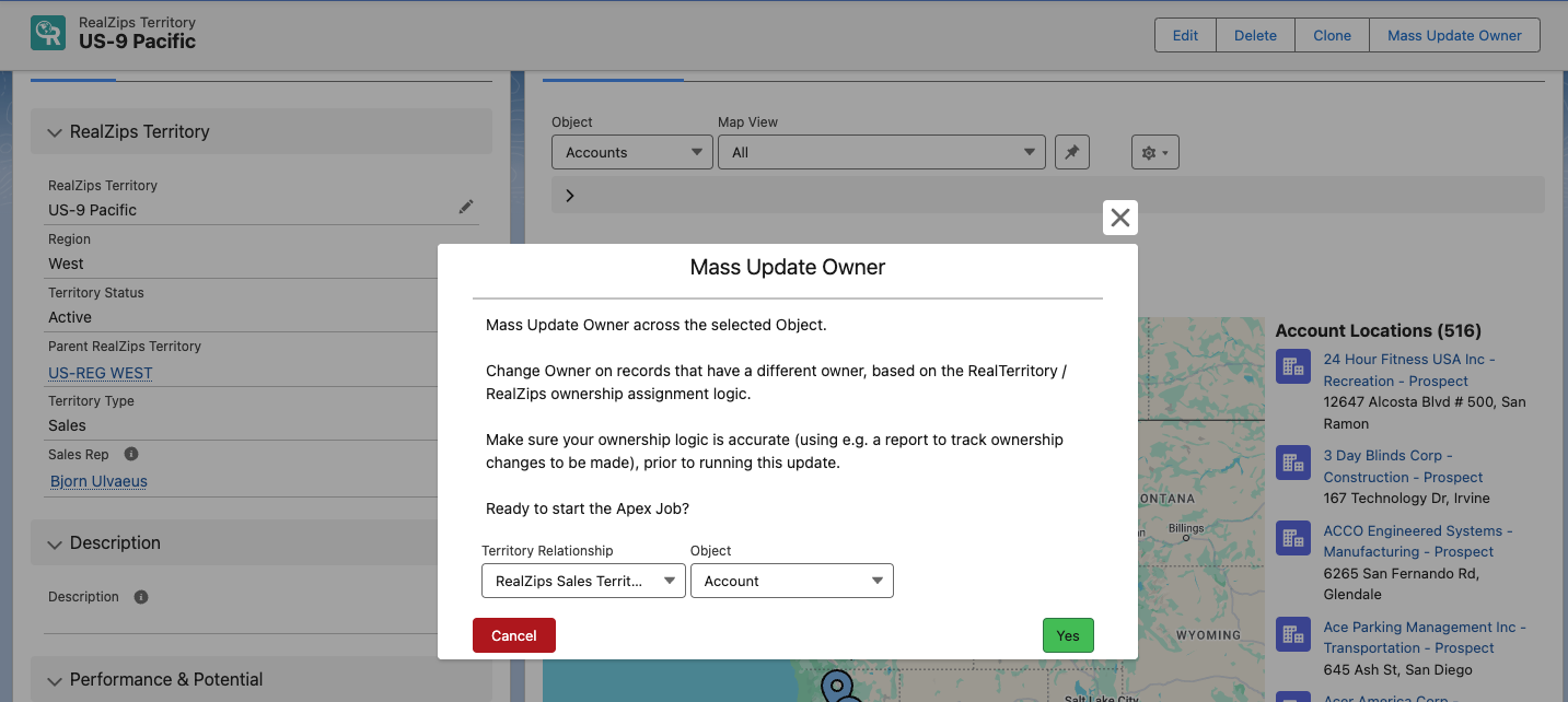
For example, RealZips automatically reassigns leads, accounts, and opportunities based on geographic data—ensuring reps get the right prospects, follow-ups happen fast, and commission payouts will be fair:
5. Align Sales, Marketing & Customer Success Teams
Sales success depends on seamless collaboration across teams. RealZips breaks down silos between sales, marketing, and customer success by providing a single source of truth for geographic customer data.
With RealZips, SalesOps can drive seamless cross-team collaboration in countless ways, including:
✅ Marketing teams can craft hyper-targeted campaigns based on regional insights
✅ Sales leaders can align teams with data-driven territory strategies
✅ Customer success teams can proactively support clients in key markets
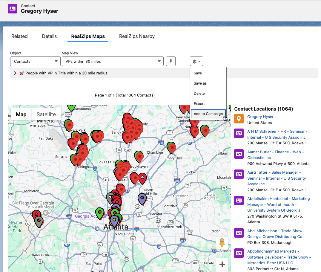
RealZips empowers organizations to manage multiple sales territories, marketing regions, and service zones—all from within a single platform, ensuring SalesOps remains in full control. The screenshot below shows how Marketing can instantly manage a Campaign based on distance from a location:
Bringing It All Together
By leveraging RealZips in Salesforce, SalesOps teams gain a powerful toolkit to:
✅ Enhance sales execution with cleaner, enriched data
✅ Unlock new revenue opportunities with market-driven strategies
✅ Automate processes to free up time and boost cross-team efficiency
More and more SalesOps teams are being asked to explore AI and Agentforce capabilities. With RealZips’ trusted geographic data and structured territories, your team can seamlessly integrate AI into Salesforce—in a matter of days.
In summary, RealZips enables SalesOps teams to turn unstructured data into actionable insights, streamline territory management, automate key processes, and foster seamless collaboration—saving time, increasing efficiency, and unlocking new revenue opportunities.
Learn more
- Salesforce Blog: 50 Sales Statistics that Reveal How Great Teams Sell
- RealZips Blog: Why add Geographic Metadata to Salesforce?
- RealZips Blog: Global Territory Management with RealZips
Ready to Unlock SalesOps Success?
Book a custom RealZips demo and discover how your team can manage territories, close more deals, and maximize your Salesforce CRM investment:
Why RealZips GeoData is Vital for Salesforce Agentforce
Organizations using Salesforce can elevate their Agentforce Artificial Intelligence (AI) projects by adding RealZips GeoData.
Here’s how the RealZips GeoData app substantially boosts the Salesforce Agentforce capabilities.
How does it work?
RealZips enhances Salesforce Agentforce AI capabilities by integrating verified, contextual datasets that ground AI results.
By incorporating RealZips’ comprehensive geographic and contextual metadata, Agentforce receives detailed and verified information on your organization’s territory assignments, local resources, channel partners, and competitive locations down to the ZIP code level, including travel distances. This enables Agentforce to generate precise, relevant content, summaries, and recommendations tailored to specific local conditions.
Here’s how your organization can leverage RealZips to automatically feed Agentforce with relevant information:
1. Enhanced Data Enrichment & Accuracy
- Geographic Precision: RealZips offers detailed geographic data, including jurisdictions, risk assessments, and territory information. This automatic enrichment of customer records is crucial for effectively training Agentforce models.
- Comprehensive Data: RealZips GeoData includes detailed information on regions, counties, demographics, socioeconomic factors, and economic metrics, providing virtually unlimited datasets from which AI models can learn.
2. Improved Personalization & Targeting
- Customized Recommendations: Agentforce can leverage RealZips to deliver recommendations based on geographic and demographic insights, offering customers more personalized and relevant suggestions.
- Segmented Outreach: By combining geographic data with aggregated sales information, Agentforce can help craft highly targeted marketing and sales campaigns, boosting engagement and conversion rates.
3. Enhanced Predictive Analytics
- Accurate Predictions: RealZips enhances Agentforce abilities to predict customer behaviors through geographic data. For example, understanding if consumers within a 10-mile radius of stores are more likely to make in-person purchases.
- Trend Analysis: With geographic trend data, Agentforce can identify and capitalize on regional patterns, such as whether homeowners are more inclined to switch insurers in areas with rising home insurance costs.
4. Operational Efficiency
- Optimized Logistics: Distance data automatically generated in RealZips can streamline routing and reduce costs for sales, logistics, or field services. Agentforce uses these insights to ensure efficient operations.
- Resource Allocation: RealZips helps solve large-scale logistics challenges by providing automated distance zones for effective planning and resource allocation.
5. Enhanced Customer Insights & Engagement
- Deep Insights: RealZips GeoData offers detailed customer demographics and regional preferences. Agentforce can use this data to derive valuable insights and make informed suggestions.
- Targeted Engagement: Geographic data allows Agentforce to design engagement strategies tailored to specific regions, such as targeting customers in areas where a product is legally sold or where incentives are available.
6. Risk Management & Compliance
- Risk Assessment: RealZips aids in assessing risks related to natural disasters, crime rates, and other regional factors. Agentforce can analyze these risks and suggest mitigation strategies.
- Regulatory Compliance: Agentforce seamlessly accesses regulatory data from RealZips to ensure compliance with regional regulations and standards, reducing legal and operational risks.
Takeaways
Integrating RealZips GeoData into Salesforce Agentforce provides a rich geographic, territory, distance, and demographic context that significantly enhances the AI’s capabilities.
Your organization can greatly benefit from improved personalization, compliance, predictive accuracy, operational efficiency, and strategic planning. The RealZips GeoData ensures the AI model will generate trusted results.
RealZips GeoData makes it possible for Agentforce to leverage the full potential of geographic information, driving innovation and delivering a competitive edge.
Next Actions
The RealZips team is your trusted partner in navigating the AI landscape. These are the steps we believe your team should consider:
- Define AI Objectives and Use Cases: Clearly outline your organization’s goals for AI and identify specific use cases where AI can add the most value.
- Evaluate Data Quality and Sources: Review existing data sources to ensure they are comprehensive and suitable for feeding into Agentforce. Identify missing data, need for metadata, and data quality issues.
- Test AI Capabilities and Risks: Conduct initial tests of AI to understand its capabilities and potential risks associated with generating content.
- Consult with the RealZips Team: Schedule a meeting with the RealZips team to discuss your data requirements and how they align with your upcoming AI projects.
- Run RealZips Free Trial: Install the free trial of RealZips in conjunction with Agentforce in your Salesforce Sandbox and assess the results to determine effectiveness.
Why CIOs Use RealZips in Salesforce and Beyond
In the dynamic landscape of enterprise IT, Chief Information Officers (CIOs) face the daunting task of managing vast amounts of data across multiple applications. Disorganized data and fragmented systems lead to inefficiencies, inaccuracies, and missed opportunities.
One tool that is gaining traction among CIOs for its ability to automate data organization and integration is RealZips. This blog post explores CIOs’ challenges with disorganized data, the importance of metadata in harmonizing data across systems, and how RealZips can deliver significant benefits to the CIO office.
Pain Points of Disorganized Data
Data Fragmentation and Integration Challenges
 One of the primary challenges CIOs face is data fragmentation. As organizations grow, they often accumulate disparate systems and applications, each with its own data repository. Integrating these systems becomes a complex and time-consuming task, usually leading to:
- Inconsistent Data: Different systems may store variations of the same data, leading to inconsistencies that complicate data analysis and decision-making.
- Data Silos: Isolated data silos hinder the flow of information across departments, reducing collaboration and efficiency.
- Complex Integrations: Integrating various systems requires significant resources and expertise, and the process is prone to errors and delays.
The Need for Metadata
Metadata plays a crucial role in harmonizing data across systems. It provides a powerful organization of raw data, enabling highly effective data management and integration. Key benefits of metadata include:
- Data Consistency: Standardized metadata ensures that data is consistently interpreted across systems.
- Improved Data Discovery: Metadata makes locating and understanding data easier, facilitating better data utilization.
- Enhanced Data Governance: Proper metadata management supports compliance and data governance initiatives.
Get Salesforce data ready for AI Use Cases
CIOs must prioritize preparing customer data in Salesforce for AI use cases to unlock the full potential of AI technologies and drive business value. Quality data is the foundation of effective AI, as algorithms rely on comprehensive, clean, and connected datasets to generate accurate insights and predictions. Without proper data preparation, AI initiatives may yield biased or inaccurate results, hindering decision-making and customer engagement.
Benefits of RealZips for CIOs
RealZips offers a comprehensive solution to the challenges of disorganized data by enriching Salesforce records with detailed geographic, territory, distance, and contextual market data. This delivers instant benefits to CIOs and their entire organizations.
RealZips Data Enrichment of Salesforce Records
RealZips enhances Salesforce records on a global scale with accurate territory assignment, geographic data, and contextual market data. This enrichment process unlocks several advantages:
- Improved Data Accuracy: By adding ZIP-code-based geographic data points, RealZips helps eliminate data inaccuracies and structures records by jurisdictions such as counties.
- Metadata Management: Organized data is easier to manage and analyze, reducing the time and effort required for data maintenance.
- Enhanced Customer Insights: Geographic and territory assignment data enables detailed customer profiling, leading to better-targeted marketing and sales efforts.
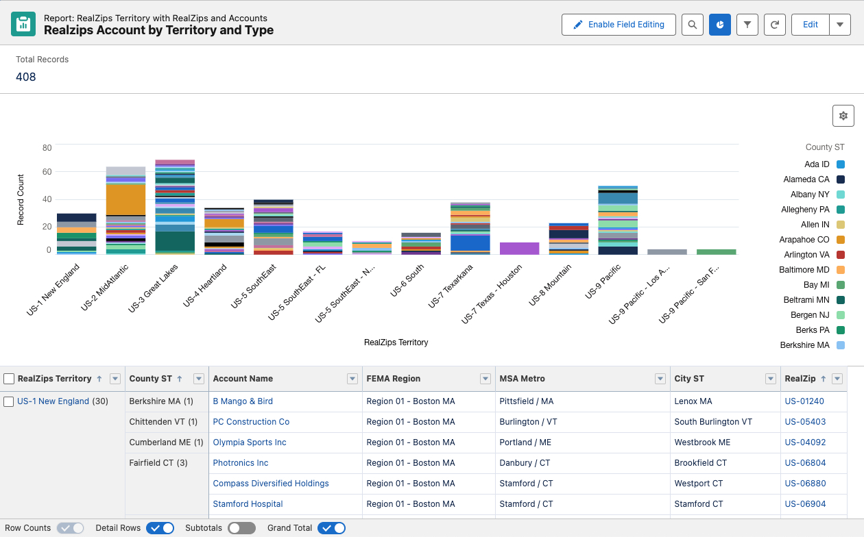
Automated Structuring Using Geographic Data
RealZips automatically structures Salesforce records with local and relevant geographic data, simplifying data management and analysis:
- Efficient Data Organization: Automated structuring ensures that data is consistently organized, making it easier to search, filter, and analyze.
- Enhanced Reporting: Local geographic data enables granular reporting and analysis, providing deeper insights into regional trends and opportunities.
- Reduced Manual Effort: Automation reduces the need for manual data entry and management, freeing up resources for more strategic tasks.
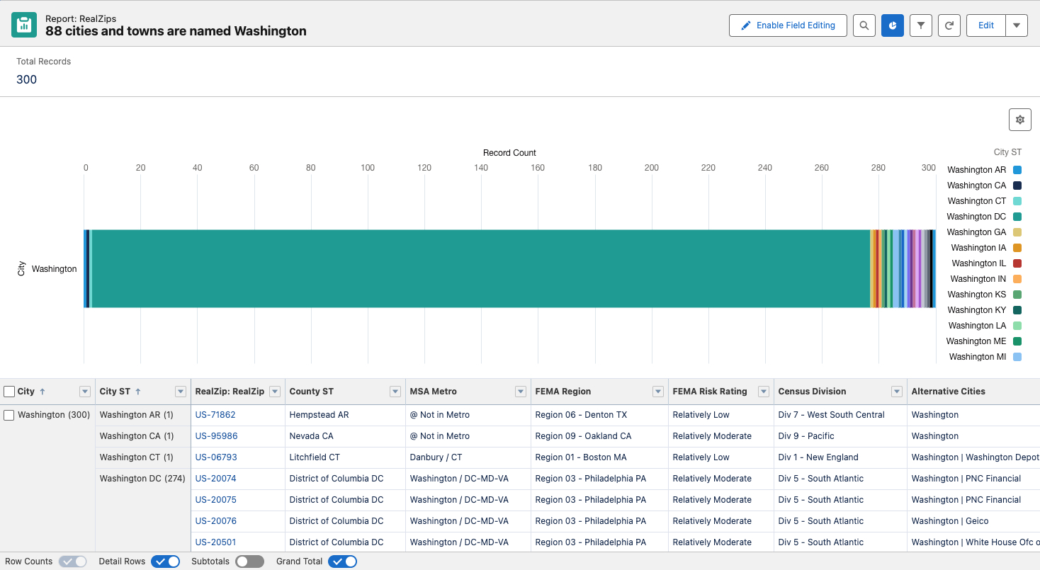
Use Case: Automated Customer Ownership and Commission Calculations
RealZips Territories automates customer ownership and commission calculations, streamlining sales operations. Commission calculations can often become very complex for global enterprise teams since data reside both in Salesforce and in the ERP system. RealZips is proven to solve the challenge as follows:
- Accurate Territory Management: Automated territory management ensures that sales territories are appropriately defined and maintained, reducing disputes and overlaps.
- Simplified Commission Calculations: Robust customer ownership management simplifies commission calculations, ensuring sales representatives are compensated fairly.
- Improved Sales Performance: Accurate territory and commission management can boost sales performance by providing fairness and clear incentives across overlapping sales teams.
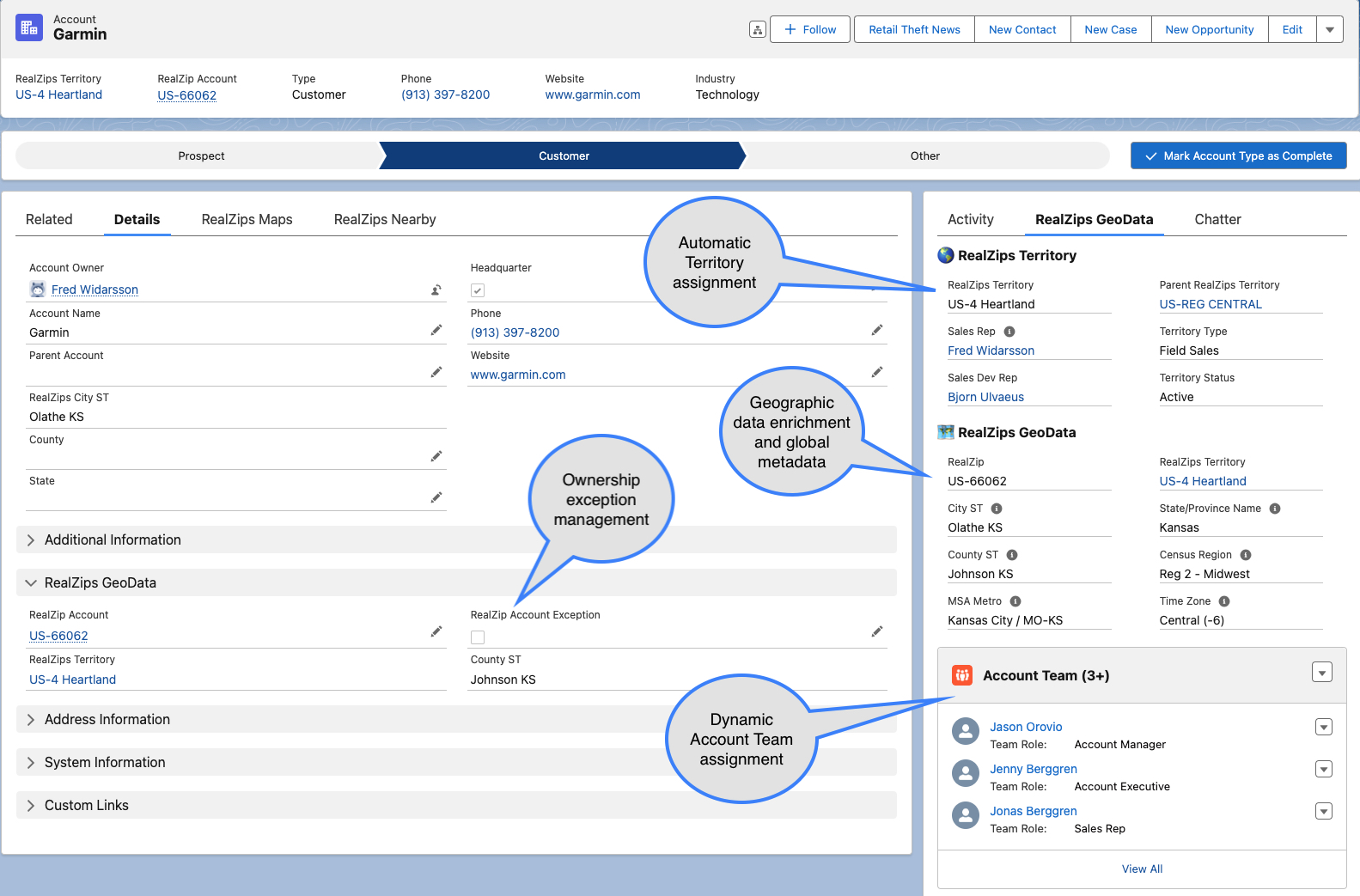
Enriched Integrations with Other Apps and Tools
The RealZips app and global geographic data improve integrations with other applications, analytics tools, and master data services, enhancing overall data management:
- Seamless Integrations: RealZips data can be easily integrated with other enterprise applications, improving data consistency and flow across systems. RealZips provides a unique key for every ZIP and postal code worldwide, which can be used in any other system for two-way data integration.
- Enhanced Analytics: Detailed geographic data from RealZips enriches BI tools such as Tableau, providing deeper insights and more accurate analyses.
- Streamlined Master Data Management: RealZips supports master data management initiatives by providing high-quality geographic metadata, which immediately improves data governance and compliance across all systems the CIO team manages.
Conclusion: Why CIOs leverage RealZips
Organizations depend on reliable and actionable data. CIOs must prioritize effective data management and reliable integration between different systems. RealZips offers a powerful solution to the challenges of disorganized data, providing geographic data enrichment, automated metadata, global territory management, and seamless integrations.
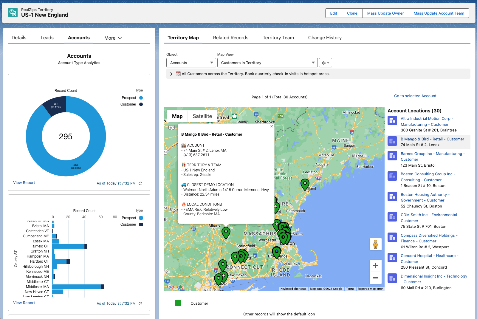
By leveraging RealZips, CIOs can enhance data accuracy, improve operational efficiency, and drive better business outcomes. Embracing RealZips is a strategic move that can help organizations unlock the full potential of their Salesforce CRM and all connected systems.
Learn more
Why add Geographic Metadata to Salesforce?
What is Geographical Metadata?
Geographic metadata refers to the detailed geographic information associated with Salesforce records, such as leads, accounts, and opportunities. This metadata provides context about these records’ location and distance relationships, enabling your team to optimize activities and automate Salesforce workflows.
Why is Geographic Metadata critical?
By incorporating geographic metadata, you will immediately remove a number of pain points and automate numerous workflows. At the same time, you will enrich and organize your Salesforce data to be used by Agentforce AI. Implementing geographical metadata today will immediately drive better business outcomes for your entire team.
Do you need data enrichment?
Not having geographic metadata in Salesforce today creates significant inefficiencies. Sales teams struggle with ineffective territory management, leading to missed opportunities and unbalanced workloads.
Without geographic metadata, marketing teams have difficulty targeting regional audiences, leading to less effective and costly campaigns. Customer service teams struggle to provide support because they cannot optimize operations based on proximity. The lack of geographic insights hinders strategic decision-making, leading to suboptimal resource allocation and planning.
Missing geographic metadata impedes overall efficiency and effectiveness across all Salesforce-related workflows.
Geographic Data Structure and AI
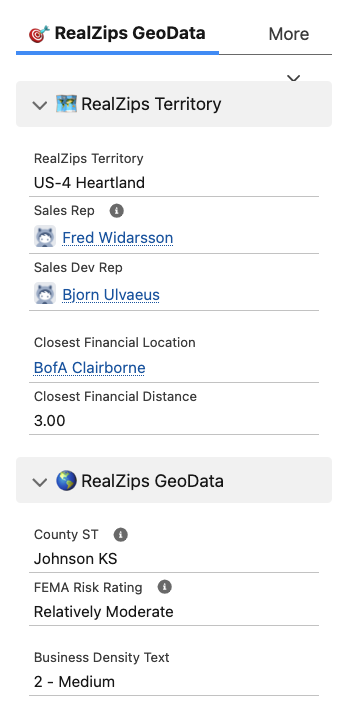
Access to verified geographic metadata in Salesforce becomes critical when introducing generative Artificial Intelligence (AI). Geographic metadata enhances the capabilities of generative AI thanks to contextual, location-based information that guarantees more precise, relevant, and actionable insights.
Here are the most common reasons why geographic metadata is critical when it comes to putting AI to work for your team:
1. Personalized Customer Interactions
- Tailored Content Generation: Generative AI can use geographic metadata to create personalized messages, offers, and content tailored to customers’ preferences in different regions.
- Localized Language and Tone: AI can adapt the language, tone, and cultural references in communications to align with regional nuances while improving engagement.
2. Optimized Sales and Marketing Strategies
- Targeted Campaigns: AI can be used to design marketing campaigns that target specific geographic regions based on local trends, demographics, and consumer behaviors.
- Predictive Analysis: Geographic data can enhance AI-driven predictive models, allowing them to forecast sales trends and market demand by regions.
3. Faster Decision-Making
- Data-Driven Insights: AI algorithms can analyze geographic metadata to identify patterns, providing decision-making insights.
- Regional Performance Analysis: Your team can use AI to compare the performance of different regions, allocating resources effectively and uncover areas for growth.
4. Improved Customer Service
- Efficient Field Service Management: AI can help optimize the deployment of field service teams by using geographic distance and metadata, ensuring timely responses and service delivery.
- Incident Response: AI can use location data to predict and preemptively address future service issues based on regional incident patterns.
5. Advanced Reporting and Analytics
- Geospatial Analytics: Geographic metadata allows AI to generate sophisticated geospatial analytics, such as heat maps and geocoded reports, providing deeper insights into regional performance.
- Contextual Analysis: AI can tap into deep contextual geographic data, leading to a better understanding of business challenges and opportunities
6. Enhanced Territory Management
- Dynamic Territory Adjustment: AI can be used to adjust sales territories based on geographic data and Salesforce metrics, ensuring balanced workloads and optimal coverage.
- Proximity-Based Assignment: AI can automate the assignment of leads, accounts and opportunities to sales reps and locations based on distance, improving efficiency and conversion rates.
7. Automated Customer Segmentation
- Granular Segmentation: Geographic metadata enables AI to segment customers more granularly, allowing highly targeted marketing and sales efforts.
- Location-Based Recommendations: AI can provide location-based product or service recommendations, increasing relevance and likelihood of purchase.
Get started with RealZips GeoData
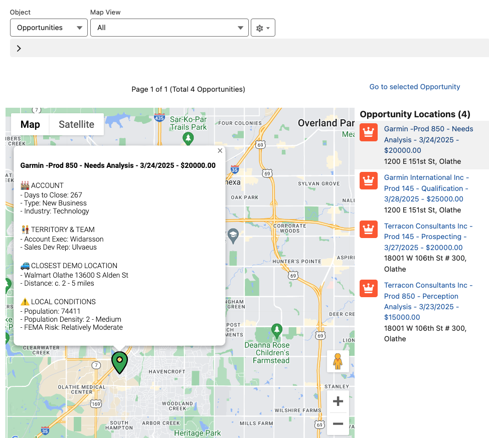
RealZips is a powerful app that automatically enriches your Salesforce records with deep geographic metadata.
RealZips can be implemented in a matter of days, instantly providing detailed geographic data and process automation.
Thanks to the rich geographic metadata in RealZips, generative AI can significantly enhance Salesforce workflows. This integration allows for localized content generation and customized offers, optimizing sales territory management, lead routing, and assigning team members and channel partners. It also enables highly targeted marketing campaigns and efficient event planning.
Finally, enhanced customer segmentation and location-based recommendations drive precise and effective marketing and sales strategies. RealZips geographic metadata grounds Agentforce AI in Salesforce, driving better business outcomes and higher efficiency.
Next Steps
- Click here to view examples of AI generated email, case summary and next actions for an opportunity.
- Learn about geographic metadata and automatic data enrichment.
Ground Agentforce with data
Can AI become a trusted solution?
Sales and marketing teams need to connect with customers on a more individual level. But how can they possibly overcome this challenge without great cost and loss of time?
To overcome the problem, cutting-edge teams are finding ways to ground Salesforce Agentforce with data. This technology opens up doors for summarizing customer records, generating email messages and automating workflows.
Marc Benioff, Chair & CEO of Salesforce, warns that AI models are “very confident liars, producing misinformation and hallucinations”. Benioff suggested during a recent earnings call that “There’s a danger for companies, for enterprises, for our customers, that these are not trusted solutions”. Benioff made the point that generative AI requires a huge dataset, including metadata so the AI technology can understand and deliver critical insights and intelligence that customers need.
This blog post outlines how to effectively ground the Salesforce Agentforce with deep datasets and metadata. We will show you how to empower your team with trusted AI results to be used across marketing and sales. But first, let’s discuss the need for data.
 How to ground Salesforce Agentforce with data
For Generative Artificial Intelligence to work, customer data must be grounded by datasets and metadata so AI models can generate trusted results.
Generative AI is only as powerful as the trusted and verified data you have access to in Salesforce. Creating useful email messages for new Leads with limited data is almost impossible. You must have access to a lot of data – deeply grounded datasets with metadata – before making attempts to use AI for marketing and sales.
Using Generative AI with limited and incorrect data will cause what’s called AI hallucinations. This is simply responses containing false and misleading information. Needless to say, this can lead to catastrophic results when it comes to customers trust in your brand.
This is where the RealZips GeoData Platform comes in. RealZips provides endless sources of verified and trusted data points for each Zip code. Every customer record in Salesforce is connected to RealZips, unlocking access to deeply grounded data.
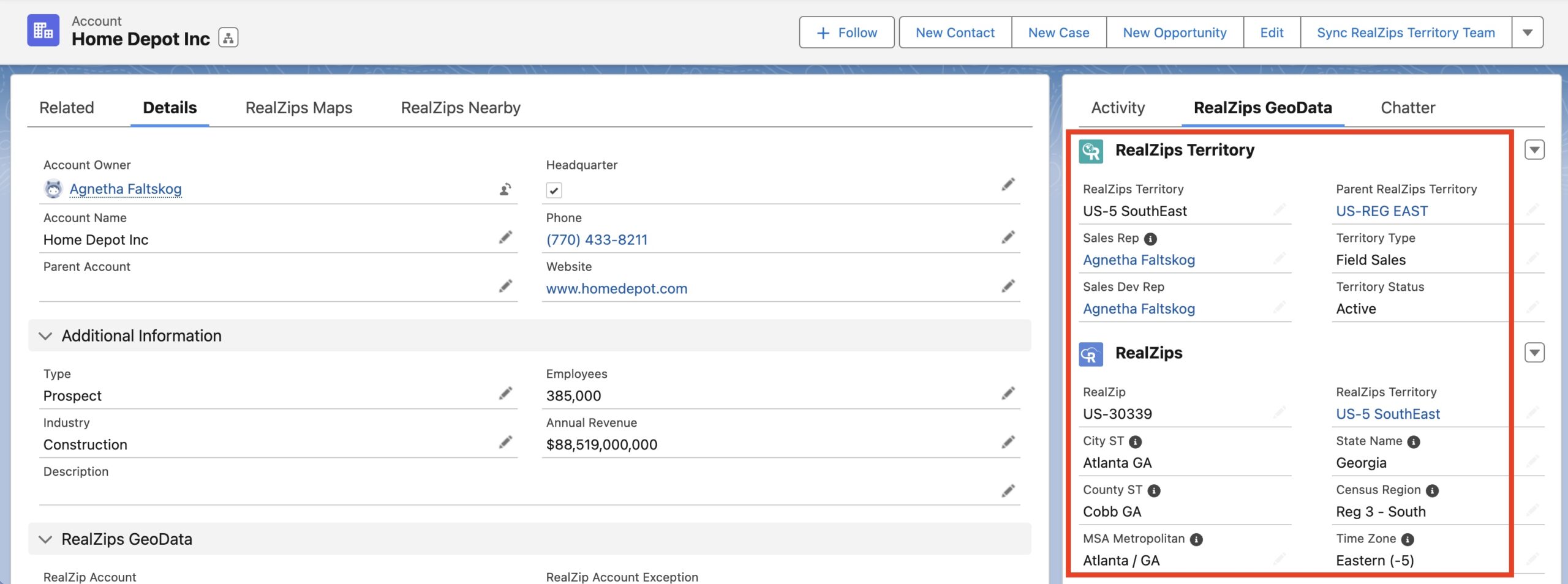
Have a look at Zip code US-33178 in Miami (screenshot). As soon as you start feeding Agentforce with these datapoints, your team can produce meaningful AI results.
Agentforce becomes grounded with deep data from RealZips. The AI technology is fed with critical geographic data points, territory teams, and meaningful statistics.
The AI technology can now tap into demographic data, business performance, risk profiles, local incentives and even laws and regulations. Agentforce can easily be taught to reference the closest sales rep, brand store or service location by distance.
Generate a Lead Summary
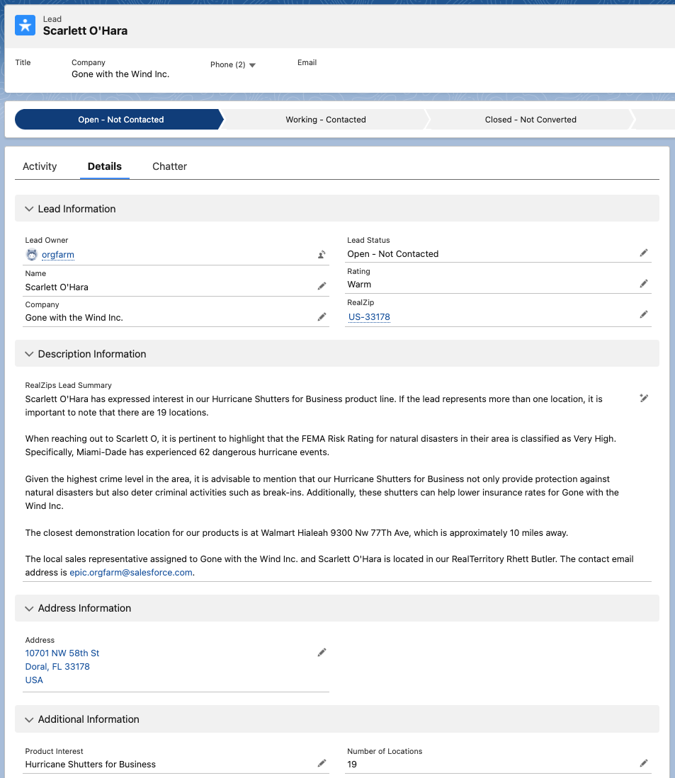
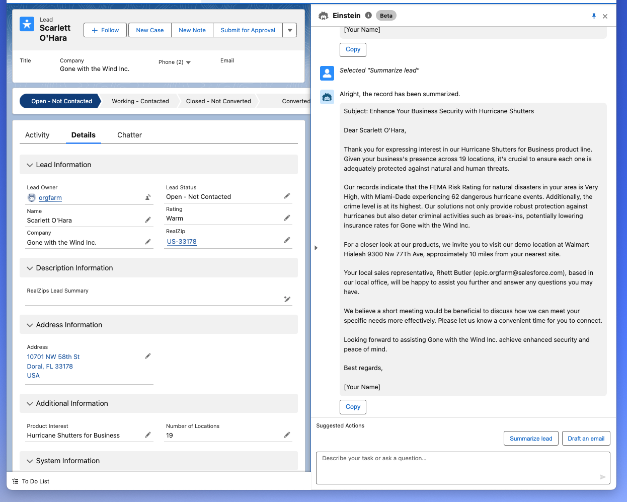
Let’s say your team is selling hurricane protection for windows and doors. The Lead record below just came in from a web form. The Lead is automatically linked to Zip code US-33178 (shown above) so Agentforce can now intelligently merge data from different sources.
By combining datapoints from the Lead and the RealZips record, the “ReaZips Lead Summary” (below) was automatically generated by Agentforce in just seconds.
Your sales team is given an instant summary, making it possible to approach Scarlett with meaningful selling points. Notice how the AI technology generates highly valuable pointers based on local hurricane risk and crime composite. The closest location where Scarlett can visit for a product demo is automatically included:
Send personalized email to Leads
Thanks to the ReaZips Lead Summary generated above, your sales team now has a solid understanding for which hurricane protection products will be suitable for Scarlett.
It’s time to make the first reach-out. Let’s start with an introductory email to get the conversation going. This is how Agentforce generates a completely custom email message in just seconds based on trusted RealZips data:
Focus on customer experience
Email messages can now be generated based on reliable data for each Lead, their specific location and your own territory team. When you ground Agentforce with RealZips data your team will save large amounts of time by eliminating tedious research and endless email write-ups. Empowered with meaningful AI data – your sales team can build meaningful connections a large number of Leads – guiding them throughout the buying experience.
AI-enabled workflows
Your own customer data in Salesforce is the perfect starting point for introducing AI into your teams workflows. You can build automated processes such as ownership assignments, and appoint internal specialists to new customers. Agentforce can be used to assign the closest available service rep to a new Case. As soon as you combine Agentforce and RealZips, you’re opening up unlimited possibilities for your team to save time and serve customers even better. The video below even shows how it’s possible to create automated action plans for Opportunities.
Video demo – Generate AI Actions
Video demo showing in real-time how to use AI to summarize customer records and propose action plans. Scrub through the chapters and learn how to use AI for summarizing Lead records, create actions for thousands of Cases, and how to generate action plans for all Opportunities:
Learn more about Artificial Intelligence
The RealZips solution can be implemented now. You can deliver successful AI outcomes immediately. Start solving endless use cases, tapping into deep RealZips datasets. These are key articles to help start your AI projects:
Salesforce Press Release
- February 27, 2024: Einstein Copilot is Here: The Conversational AI Assistant for CRM that Delivers Trusted AI Responses Grounded with Your Company Data
Salesforce Blog Posts & News
- March 6, 2024: Einstein Copilot In-Depth: What It Is, How It Works, and What It Can Do
- February 29, 2024: Why Every AI Project Should Begin as a Data Project
RealZips Posts
- October 12, 2023: Prepare your Salesforce data for the AI revolution
- March 5, 2024: Improve your data in Salesforce with RealZips
- Integrate Market GeData & GeoData Insights with existing customer data
- Knowledge Article: How to configure Einstein Pilot with RealZips GeoData
Improve your customer data in Salesforce with RealZips
Why should you consider the RealZips app for Salesforce?
The RealZips GeoData Platform structures and organizes your customer data in Salesforce automatically, empowering your team to connect faster with the right customers in the right places.
 Problem: Deterioration of customer data
Organizations are rapidly adding large amounts of customer data to Salesforce. As more data is added, the ability to search and report on customer data deteriorates.
Your customer data is becoming more and more disorganized over time, severely limiting your teams’ ability to run targeted marketing campaigns and focused sales activities. When consistent and structured geographic data is missing across records, your team can no longer use customer data efficiently.
Solution: Organize customer data geographically
The RealZips app provides a mission-critical geographic data structure for your customer data in Salesforce. Every record in Salesforce is automatically related to zip code or international postal code. Each zip code holds a wealth of deep geographic information, which automatically organizes and improves your entire customer database.
Your team will be able to instantly search and report across customers and territories, using endless geographical dimensions such as cities, counties, MSA Metros. Deep contextual data for each Zip code will guide your teams activities to the best possible geographic markets.
Tap into local market conditions with deep data
RealZips provides unlimited contextual market data, related to consumers, businesses, business risk, and other local conditions. You can automatically rank every Zip code based on market potential, and compare against your current sales performance.
Jurisdictions such as states, counties and cities often have a great impact on your ability to market and sell. Once you implement RealZips, your team can automatically categorize prospects based on state-based incentives, local laws and regulations, consumer and political preferences, climate conditions, crime risk and much more.
Implement distance zones for marketing, sales & support
Logistics is a key factor in your team’s ability to succeed, even if your team is working 100% remotely. For example, if a prospect is closer to a competitive location, your team is at an immediate disadvantage.
The RealZips app allows you to automatically organize all records in Salesforce by distance to your own locations and competitive outlets. Every customer record will be given a score based on competitive risk and serviceability. In turn, your team can now optimize marketing, sales and support activities based on distance zones.
Unlock Success: Data-driven territory management in Salesforce
A critical key to success for any organization is territory management; automatically assigning prospects and customers to territories and best-fit team members. Creating territories is a data-driven process, requiring robust geographic data, deep market data and your own sales data.
The RealZips app enables your team to use deep data for each zip code while creating and updating territories. Each Zip code can now be treated as a micro-market, comparing market potential against sales results.
Distance calculations are used to automatically predict your teams ability to serve customers in the Zip code. Every Zip code can be served by multiple territories, efficiently managed by the RealZips app.
Which organizations benefit from RealZips?
Organizations with many records in Salesforce will enjoy instant business value from RealZips. If your Salesforce database is burdened with legacy automation (old workflows, process builders, custom APEX) you will rapidly benefit from RealZips, using out-of-box RealZips automation.
RealZips GeoData is proven to empower organizations across all industries, ranging from non-profits to the financial industry. The more data you are managing in Salesforce, the faster you will achieve business value from RealZips.
Organizations that must focus on geographic areas with the highest sales potential (not having an unlimited marketing and sales budget) are very likely to get in touch with more prospects and close more opportunities shortly after implementing RealZips.
Answer these 8 questions and learn if you need RealZips
If you are getting more than three “Yes” responses, you and your team will benefit from adding RealZips GeoData to your Salesforce customer data:
- Is your Salesforce customer data missing geographic data points?
- Does every customer have critical territory team assignments, and distance to closest team member?
- Can you drill-down into customer data across regions, territories, state, counties and MSA metros, and cities?
- Is lead routing already an issue, with hard-to-manage rules and overlapping automation?
- Are you running out of Salesforce Enterprise Management Hierarchies and Territory Assignment Filters?
- Does your Salesforce Org have complex automation for sharing rules, ownership rules and territories?
- Does your marketing team struggle to run campaigns by metropolitan areas and travel distance to venues?
- Does the sales team miss data on where to focus their sales activities, based on local market potential?
How soon should I expect results from RealZips?
The RealZips app can be up and running rapidly. Oftentimes the customer data can be automatically structured into geographic areas and territories on the first day for implementation.
Depending on your Salesforce ORG’s complexity, the RealZips time to value usually varies between immediate value and up to a few weeks to be fully implemented.
What will the RealZips team bring to the table?
Consider the RealZips team your trusted partner in unlocking your team’s sales success. We have 30+ years of experience from global CRM implementations, across most industries.
Prepare your Salesforce data for the AI revolution
You’re ahead of the AI game
Teams using Salesforce have a tremendous advantage when it comes to rolling out Artificial Intelligence capabilities. Salesforce is quickly adding AI features on top of your existing customer data allowing you to rapidly unlock potential cost savings and revenue gains.
RealZips delivers shortcuts to getting value from AI,
eliminating the need to run data cleanup projects.
Tap into Artificial Intelligence
AI technology is rapidly becoming available and 84% of leaders agree that generative AI will serve their customers better. A whopping 92% of large businesses that already have invested in AI are seeing returns.
Make sure to start testing existing AI capabilities in Salesforce already today, learning how to make predictive analytics. Keep a close eye on what’s gradually becoming available in the promising generative AI space right inside your Salesforce organization.
The data problem
Bad data quality and missing data are major hurdles for most organizations as they start tapping into AI opportunities. The premise of the new AI technology is however limited by the quality of your own data in Salesforce.
Hard way: Scrub your Salesforce data
There are few shortcuts to improving your data, while preparing for AI-driven workflows. Here are a few common approaches for getting your data in shape:

- Update Account records with address, industry and key data points.
- Update Contact records with address, title and valid email.
- Look into services that test if contact email addresses are active.
- Harmonize and standardize picklists where possible.
- Implement methods for record deduplication.
- Identify old open Opportunities and start cleaning up.
Once you start digging into customer data that’s been added over time, chances are that even a small data scrub project will take a lot of time and effort.
Keep in mind you probably have apps connected to Salesforce that use existing datapoints. Your Salesforce automation is very likely to use ‘bad data’ which makes data cleanup harder.
Easy way: Add RealZips GeoData
The RealZips app creates an automatic relationship between a Salesforce record and endless datapoints on the related zip code record. Instantly, you’ll have access to datapoints from the zip code, such as city, county, state, territory, and much more. Data you can add is actually endless. Have a look at the thousands of datasets available in our online store: RealDatasets.com
RealZips gives you immediate shortcuts for tapping into AI, since the RealZips app automatically augments existing data by adding contextual data to your records. For example you can geofence all customers by county, and prepare for AI predictive analytics by county!
Don’t break integrations, searches, reports & dashboards
The RealZips app does not need to change any existing data, making the implementation of RealZips completely risk free. RealZips is simply bypassing all the problems associated with updating existing data fields to new values.
Most of us have seen data update projects break app integrations, mess up searches, render list views useless, distort function formula calculations, not to mention making critical reports and dashboards useless. RealZips makes it possible avoid these issues simply by delivering a data augmentation solution.
Add automatic contextual data
Contextual geographic data unlocks tremendous possibilities, that your team will be using every day across marketing, sales and customer support.
Think about contextual data as an automated process that provides critical market conditions for each record in Salesforce. Contextual data makes it possible to focus marketing and sales in geographic areas where your team is most likely to deliver success for your customers.
Examples of contextual data from RealZips, used to improve all records in Salesforce:
- Local incentives that will help your team sell a product or service.
- Local laws and regulations that may promote (or block) the sale of your product.
- Automatic geofencing by for example county, organizing customers by local jurisdictions.
- Travel distance between sales team members and prospective customers.
- Distance between open opportunities and your own service locations.
- Distance between existing customers and your competitions’ closest locations.
- Insights into your customers’ customers: age groups, income and consumer preferences.
- Weather conditions such as sun hours per year, climate zone and FEMA based disaster risk.
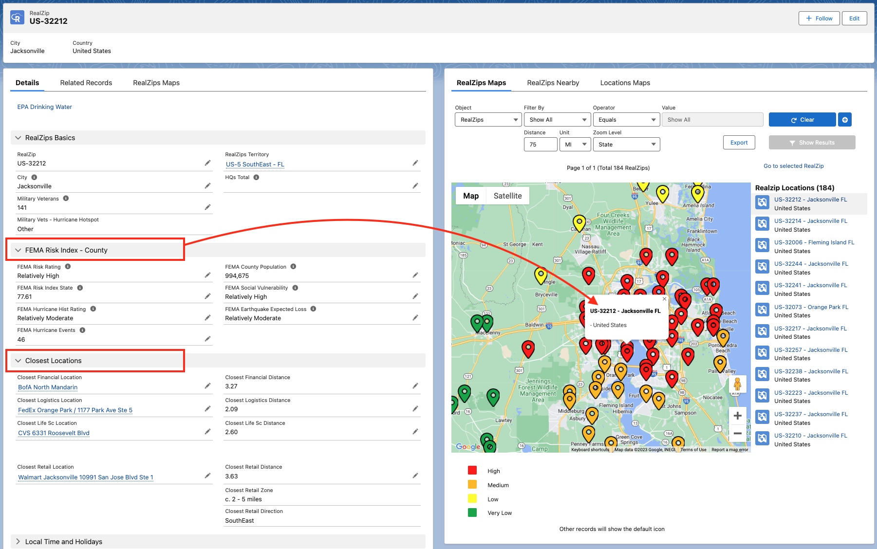 Contextual data, providing risk for natural disasters. Distances for key locations – closest to each zip code – are automatically calculated.
Explore AI capabilities, powered by contextual data
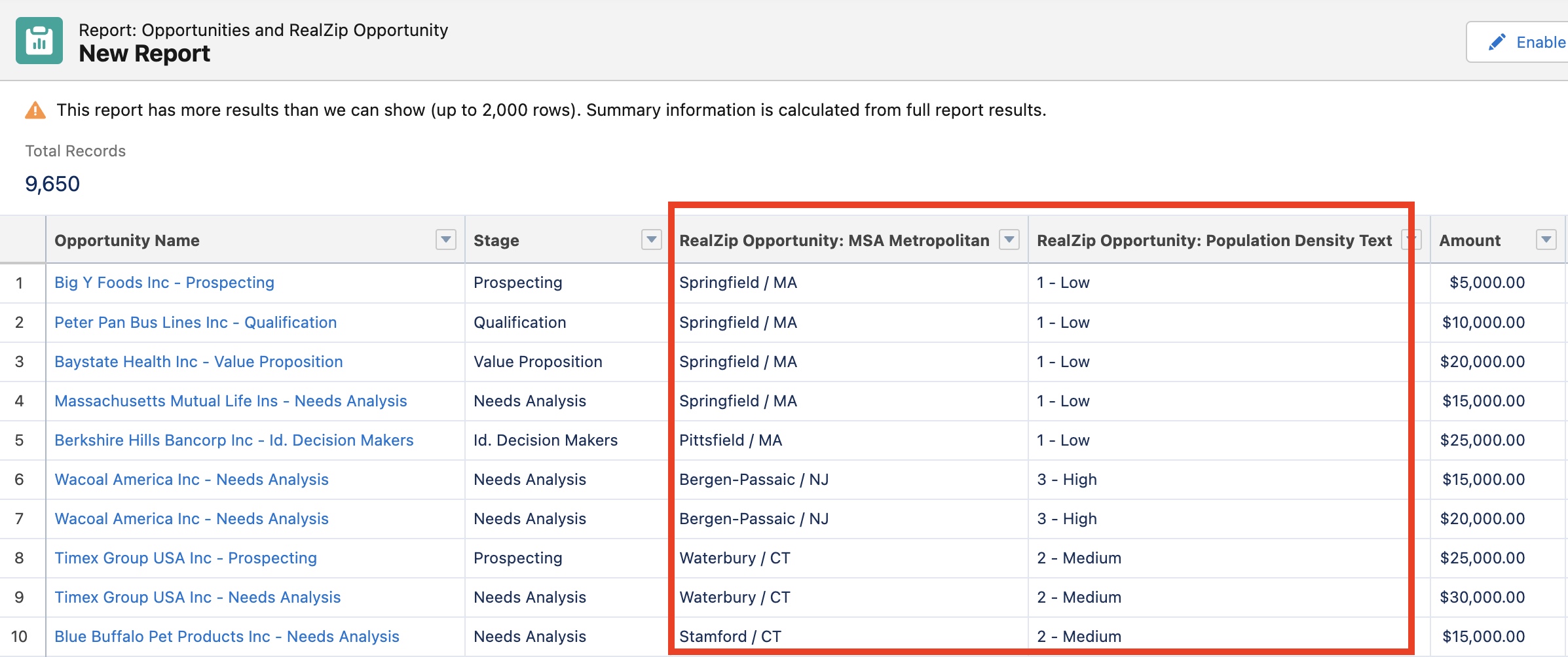
Let’s say your team believes they are closing more Opportunities inside Metropolitan areas, with a really high population density.
You can test out the theory by adding RealZips data points such as ‘MSA Metro’ (your geofence) and ‘Population Density’ to all Won Opportunities. Next, run the Salesforce Einstein Prediction Service across the Opportunities and learn if the theory holds up.
Prepare for AI success
It’s possible to kick-start your team’s AI journey simply by adding RealZips contextual geographic data to your records in Salesforce in a matter of hours. Install the RealZips free trial from the AppExchange and launch your AI success journey.
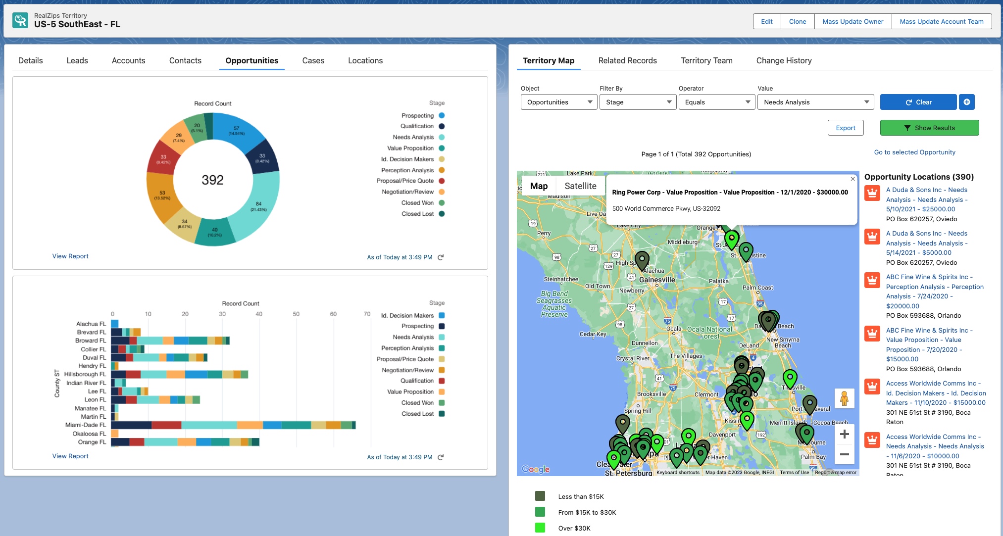 Prepare for AI success by organizing all records by territories and geographic zones. Close more deals – by applying AI predictions – based on your own data and RealZips geographic data.
Learn about Salesforce Artificial Intelligence capabilities: AI for Sales and CRM
5 reasons to add RealZips to your Salesforce ORG
RealZips is a data-driven territory management app for Salesforce. RealZips automatically organizes and enriches global customer data records in Salesforce.
Use cases for RealZips range across all industries. The reasons for implementing RealZips are surprisingly similar across different organizations.
These are five common challenges that RealZips will address, enabling you to deliver a better Salesforce User Experience:
- Data Enrichment
- Territory Management
- Actionable Market Data
- Salesforce Automation
- Customer Focus
RealZips is designed to help your team save time and connect faster with customers. Let’s have a look at how you can solve these 5 challenges by implementing RealZips:
1. Data Enrichment
Lack of data points across your Salesforce records cause endless problems and inefficiencies.
Marketing can not effectively segment leads or run marketing campaigns in best-fit geographic areas. Sales can not automatically assign prospects and customers to the right sales resource. Assignments of Cases are delayed, creating friction with your customers.
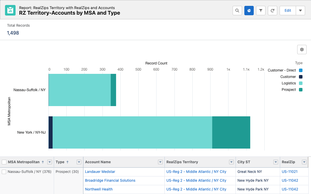
The Zip code and Country fields on your Salesforce records are used to automatically relate endless data points from RealZips app.
For example, all customer records can instantly be enriched with data points such as city, county, state, MSA metro, time zone, sales team, closest store, and more.
Data enrichment unlocks new ways for marketing, sales and operations to better serve customers.
These are examples of what you will be able to do with RealZips:
- Add time zones to all records in Salesforce, so your team can time mailers better and schedule outbound calls at the best possible moment.
- Activate County and MSA Metropolitan data points, allowing you to automatically group prospects into manageable sub-territories. Your team can now run perfectly targeted marketing campaigns and sales activities.
- Set up automatic Drive Zones around sales and service team members, organizing customers records by distance. Enable your teams to maximize time with customers.
2. Territory Management
It’s virtually impossible to provide your team with a scalable Territory Management solution, complete with interactive maps, dashboards, and integrated reports.
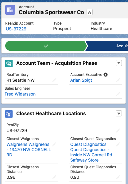
The standard Salesforce Enterprise Territory Management (ETM) does not support granular territory management on a Zip code level. Most organizations therefore struggle to manage smaller geographic territories, that divide states and cities. Overlapping territories is another major challenge, as territories are stacked on top of different sales teams, service teams and channel partners.
Home-grown workarounds for Territory Management quickly become confusing and impossible to manage. For example, sales teams must oftentimes use multiple dashboards, reports and links to mapping tools to understand the geographic assignment and ownership of customer records. Salesforce Admins are then forced to build a dizzying array of automation for owner assignment and Sharing Rules.
RealZips is designed to deliver a data-driven, reliable and scalable solution for Territory Management.
RealZips provides a platform for territory management, completely integrated with global customer data in Salesforce:
- Out-of-box Territory Dashboards for immediate rollout
- Territory assignment templates for instant territories
- Management of overlapping territories across the world
- Map components for any Salesforce page
- Sales team management and ownership automation
- Rules-based territory teams, displayed on Salesforce pages
3. Actionable Market Data
Market data outside of Salesforce is very important, providing insights for strategic planning of marketing and sales teams. Stand-alone market data can range across demographics, consumer behavior, corporate data, regional incentives, local risk exposure and more. The problem is… it’s outside of Salesforce!
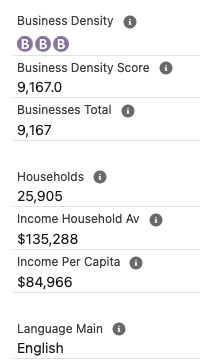
The day you start moving market data metrics into Salesforce – combined with existing customer data – is the day you’re creating a substantial competitive advantage for your team.
Market data provides a framework for where to engage in marketing campaigns and sales activities, once the data is in Salesforce. The RealZips app was designed to blend your own customer data with deep market data.
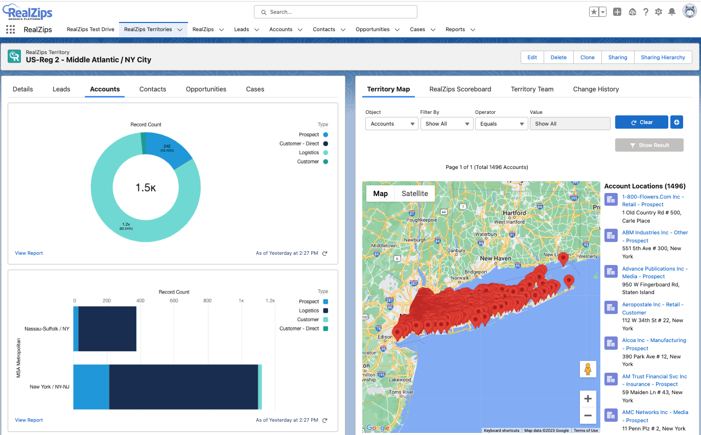
Samples of Zip codes based demographic datasets, available in the RealDatasets.com store. These datasets can rapidly be uploaded into RealZips and integrated with existing records in Salesforce:
RealZips automatically combines customer data and market data, ranking geographic areas and customers based on local market conditions. For example, all prospective customers can be flagged for local incentives, changes in real estate value, or demand for product and services.
Market data in Salesforce opens up endless possibilities to understand each customer’s local market conditions.
The RealZips app makes it easy to add actionable market data of any type to Salesforce. Here are a just a few examples:
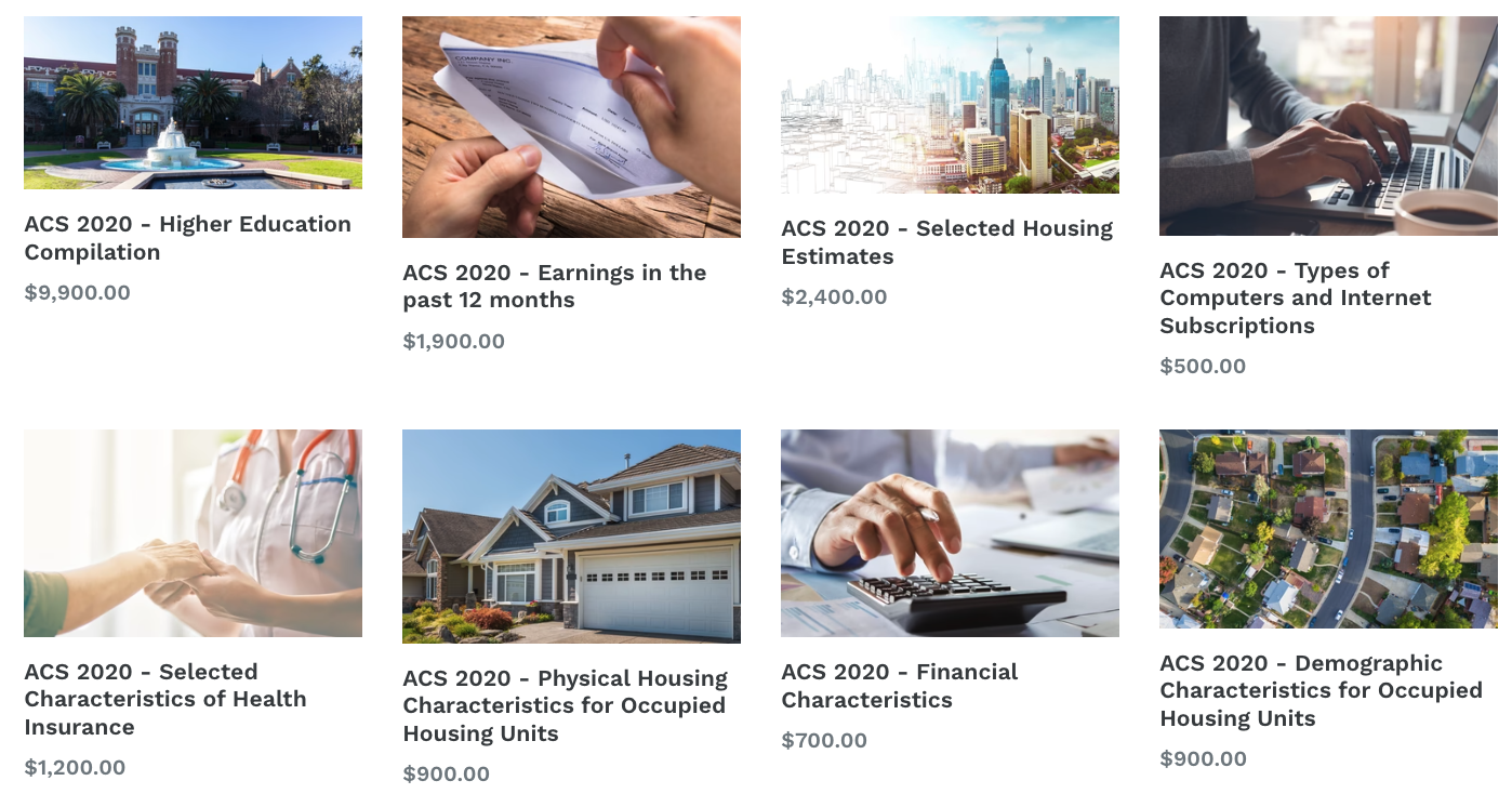 The market data you choose to add, can immediately be added to existing customers records. Prospects and customers will automatically be ranked based on market conditions, distance to sales and service locations, and much more.
Market data in RealZips sets a framework for automating processes, and allowing your team to make instant decisions across territory design, marketing campaigns, and daily sales activities.
4. Salesforce Automation
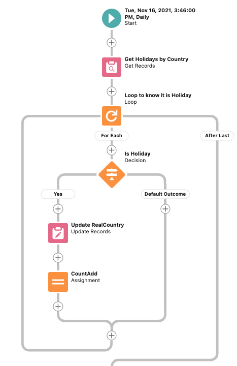
Trying to automate business processes in Salesforce with missing and incorrect data is a tremendous challenge.
Most attempts to automate processes will be limited to the quality of your existing data.
The Salesforce Cloud has fantastic capabilities when it comes to automation, especially when using Lightning Flows.
However – without useful data points to use in the automation process and logic – you can not make full use of Salesforce Automation capabilities.
RealZips takes your automation and Lightning Flows to new level :
- Automate assignment of leads by combining territory information, geographic data and market data.
- Configure flexible rules-based sharing of accounts, contacts, opportunities and cases.
- Create assignment logic based on distance zones, applicable to stores, service locations, and sales team members.
- Geographic markers such as County, MSA Metro, Territory and more can be used in your automation logic in virtually unlimited ways to speed up your teams’ workflows.
RealZips provides built-in features for lead routing and ownership assignment, used by large global organizations to keep massive amounts of records assigned to the right team members.
5. Customer Focus
The RealZips app and data was designed to empower your team to focus on the right customers, in the right places, at the right time.
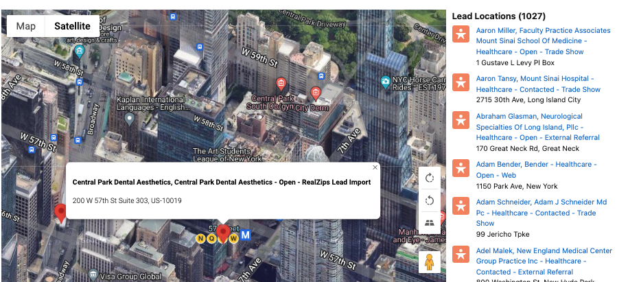
How RealZips unlocks your team’s customer-first focus:
- RealZips GeoData organizes your customer data into a geographic framework.
- RealZips Territories makes it possible to roll out a powerful global assignment of internal resources.
- Market Data provides local market conditions, used to drive marketing, sales and support activities.
Salesforce Automation enriched with RealZips makes it possible to build meaningful workflows that help your team focus on what matters most: Customers.
RealZips App for Global Territory Management in Salesforce
Are you planning to expand your business new markets or even globally? Or do you already have an international footprint? No matter the case, the RealZips app streamlines global territory management across you Salesforce CRM data.
When expanding your business geographically, you likely have three critical questions in mind:
- Are we targeting the right geographic areas?
- Do we utilize the right local resources?
- Are we meeting with the right customers?
A data-driven global territory management app running in your Salesforce organization is a must for addressing these questions. The RealZips app is designed to enable your global sales teams to gain insights and drive success.
The RealZips GeoData Platform is one-of-a-kind Salesforce business process management software, since it’s powered by deep geographic data.
RealZips effectively organizes resources across geographical areas, encourages deep collaboration between multiple sales teams, and help your team focus marketing and sales activities in best-fit geographic areas. So, if you want to become a global leader in your industry, this geo-targeting software is a must-have for business.
RealZips Global: Transform your business with geodata insights
This RealZips Platform offers a dynamic global geodata structure that seamlessly enables enterprise territory management. International businesses with multiple branches and sales teams are seeing major challenges such as increasing local competition, and risk of internal overlaps and more. Such challenges can sometimes make survival harder in the industry because everything becomes dependent on the adaptability and alignment of internal resources with both existing and future customers. With RealZips data-driven and global sales-territory management software, you can mitigate these risks.
A 4-step approach to implementing RealZips and driving sales success
The RealZips GeoData platform primarily makes use of this 4-step approach to help you with strategic territory management:
1. Set a Global Territory Management Structure
The RealZips enterprise territory management app for Salesforce is an innovative and feature-rich tool for global enterprises. Being powered by zip codes, postal codes, partial postal codes, and deep market data, this app delivers global coverage, allowing for dynamic assignment of countries, states, cities, metropolitan areas, provinces, etc. You can plan and execute your marketing and sales efforts, based on the depth of these different geographic areas.
Over time, you can instantly add more granular postal code data all countries in the world. Click here to see learn more about deep postal code data for France and Germany.
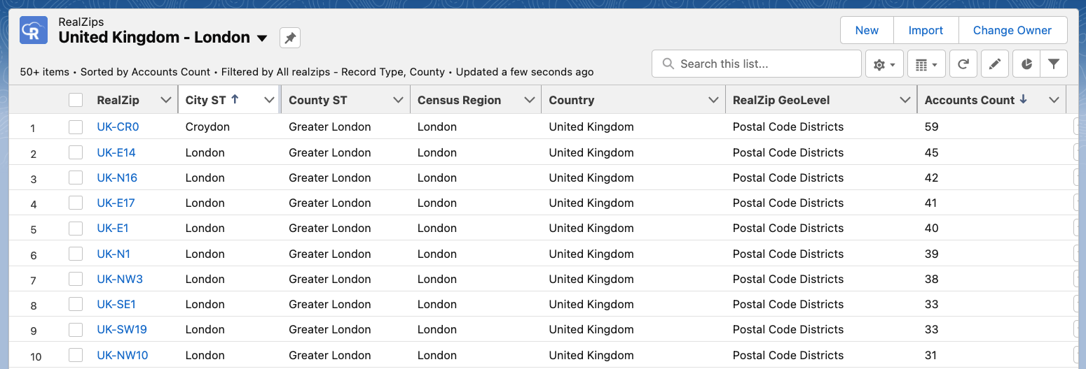
In the example below, the United Kingdom is dynamically divided by partial postal codes. Pay close attention to how the postal codes have different lengths. For example “E1” and “NW10” both represent a single postal code area, effectively managed by the software logic built into the RealZips app:
2. Sales Territory Assignment
Once the geographic structure is in place, the app allows you to proceed with sales territory assignment. The well-designed sales territories, in combination with effective territory management, attract more sales and give you great market coverage. Apart from it, you can offer better services to your customers.
RealZips allows you to:
- Assign complex team structures and overlapping territories across geographic areas.
- Manage your channel partner territories.
- Support growth with the inside sales team and lead assignment
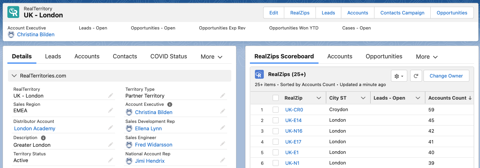
The image below shows the territory for Greater London, complete with team members and a listing of postal codes with the most Accounts in:
3. Align your Salesforce data automatically with Territories
RealZips Salesforce CRM data allows for real-time resource allocation and territory ownership assignment. Your existing Salesforce records will automatically be assigned to a territory.
The RealZips assignment rules, when applied to your Salesforce data becomes is very powerful. You can rest assured that leads are assigned properly, and ownership of customers is always correct. . Each team member can immediately review the team managing a geographic area, and ensure instant collaboration to support each customer.
The lead assignment rules work on the basis of company size and product interest. Therefore, leads are instantly routed to the best-fit resource. In addition, your team will enjoy the RealZips “Nearby’ and Closest’ features, as they get deeper into using the application for daily planning, marketing campaigns, and sales activities.
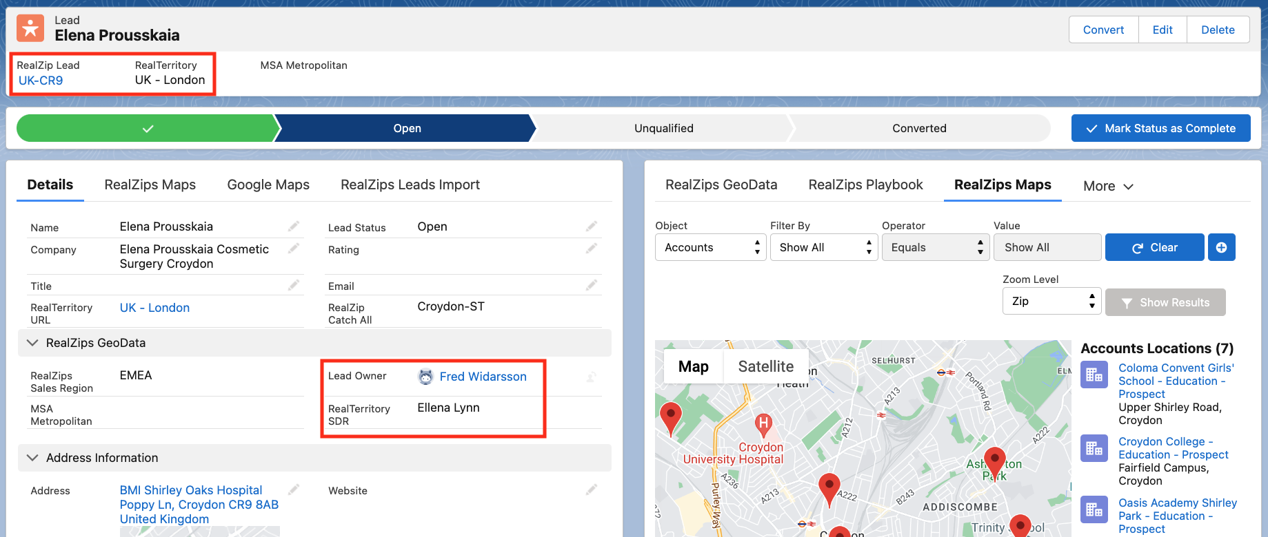
In the image below, you can see lead being automatically assigned to a territory:
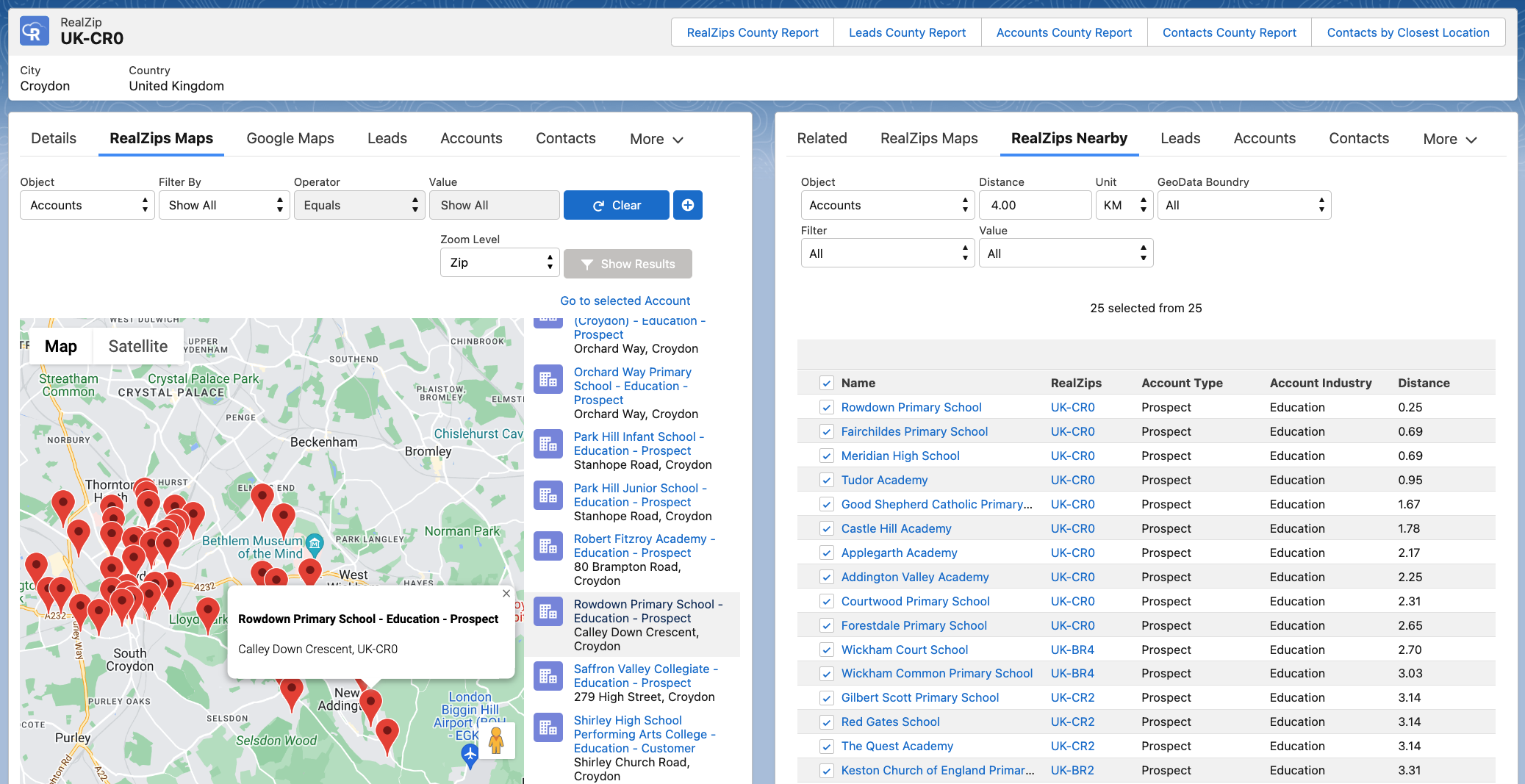
The image below shows the RealZips Nearby feature, used to identify prospects within a selected radius:
- Left side Lighting component: RealZips Maps provides an interactive map of Accounts in the area
- Right side Lightning component: RealZips Nearby let’s you set a radius of e.g. 4 km and drop all records into a Salesforce Campaign
4. Measure Sales Success through Global Territory Reports
Sales metrics play an important role in measuring sales performance and analyzing the success rate of the business. The RealZips GeoData Global territory management software output the global data analytics that help you to easily measure global sales across different marketing channels and campaigns, lead generation, opportunity pipeline, and revenue growth.
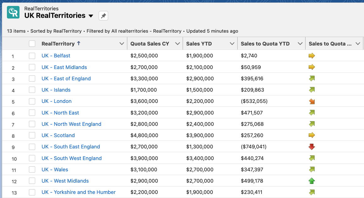
The image below accentuates the performance across sales territories the United Kingdom. It enables the company to quickly allocate resources for optimal growth across any market as well as sales territory:
Discover new opportunities with RealZips GeoData Global Territory Management in your Salesforce
The RealZips GeoData app can help you easily identify new opportunities in the international market and take your company to the next level.
This fully Salesforce-native app has extensive enterprise territory management features and lead assignment rules that help you easily automate business processes, manage global territories for channel partners and internal teams, and analyze sales performance. It further allows you to make better decisions and drive business growth.
To learn more and request a demo, please visit
https://www.realzips.com/products/global-data-management/
AppExchange Blog: How Location Can Affect Your Selling Potential
Read our guest blog post on the AppExchange and the Salesforce Ecosystem blog:
https://medium.com/inside-the-salesforce-ecosystem/location-affects-selling-f42dab2807
Run GeoTargeted Marketing with RealZips in Salesforce
Organizations that use RealZips in their Salesforce drive marketing success. This is how they leverage RealZips within their GeoTargeted Marketing.
Lead Generation Challenges
Marketing teams have a tremendous responsibility of finding and qualifying best-fit leads for sales. However, it’s not uncommon for marketers to unknowingly deliver low quality leads to the sales team, overwhelming the sales pipeline with incompatible prospects.
Figuring out which leads are best suited for a sales team is oftentimes a complicated process. Lead profiling is often based upon metrics related to the industry, company size, decision-makers’ access, buyer intent, creditworthiness, and more.
Location data is often neglected in lead profiling because the marketing team has little or no supporting data for meaningful geotargeting. This lack of user location data makes lead generation inefficient.
Half the money I spend on advertising is wasted;
the trouble is I don’t know which half.
— John Wanamaker
Switch to RealZips Geotargeting
When your team utilizes geotargeting with RealZips, it becomes possible to leverage location data throughout the entire lead generation process.
These are the six basic methods to use RealZips for your geotargeting efforts, helping you generate sales success:
Geographic boundaries. Existing boundaries such as states, cities, and sales territories play a critical role in effective lead generation. For example, using County Business Patterns (CBPs) as part of a framework of lead generation is proven to be very effective.
Industry hotspots. Similar companies tend to be clustered geographically. It’s essential to break down Total Addressable Market (TAM) into geography-based industry hotspots from a geo-targeting lead generation perspective.
Local economy. The economic outlook in MSA Metropolitan areas will have a direct impact on lead generation. Economic factors can range across people moving to or from an area, shifts in local unemployment levels, changes in state and local taxes, fluctuations in building permits, competitive organizations setting up outlets and offices, and much more.
Proximity planning. Sales teams often prefer lead generation in concentrated areas such as near airports, close to their stores and field offices, and even far away from competitive locations. Companies with a proximity strategy for lead generation tend to reap substantial benefits related to logistics.
Action triggers. Marketing teams using action triggers in their lead generation have a competitive advantage. They use time zones as a powerful action trigger, sending outbound emails at the best possible local time. Sellers of electric cars may use local gas pricing as an action trigger, spending more on lead generation as gas prices rise.
External data. External data managed in RealZips opens up endless possibilities for lead generation. For instance, use sun hour data by zip code to sell solar panels, leverage local water quality data to provide filtration technology. Tap into flooding and hurricane risk data to provide insurance or new building technology. Leverage financial incentives issued by state and local agencies to promote your products and services. There are no limits to how external data can be used within the RealZips platform, driving success across both marketing and sales.
Generate Quality Leads with GeoTargeted Marketing
Organizations that properly use these methods for geotargeting will likely see an increase in their best-fit lead generation.
The goal is to deliver market-qualified leads in the best possible geographic locations, allowing the sales team to close deals faster. Save time by eliminating leads that are hard to service and avoid marketing in areas where there are few reasons to purchase your product or service.
Quality Over Quantity
Lead generation is about reaching the right prospect, located in the right place, with the right message, at the right time.
When you deliver leads to your sales team, quantity is not always better. If they end up disqualifying a high percentage of leads, your team will lose valuable selling time. Additionally, they may even start doubting if the lead generation process works.
Improving the lead generation process seems to work very well for many organizations, initially setting focus on generating high-quality leads in the best-fit locations. Once the quality of marketing-generated leads meets the needs of the sales team — it becomes possible to increase the number of leads — while maintaining a high close rate.
Next Steps
With RealZips GeoTargeted Marketing, the marketing and sales teams can align efforts and deliver results. RealZips has the potential to enhance your geotargeting, boost your lead generation, and close more deals.
Can Missing Geodata in Salesforce Limit Your Teams’ Success?
The Salesforce CRM platform is fantastic, empowering your team to connect faster with customers, partners, and potential clients. Salesforce is the number one software for customer success, helping organizations like yours manage customer activities and stay in constant touch with all your stakeholders.
However, there is a challenge when it comes to your own data in Salesforce. The data that your team manages is not structured into critical geographic structures such as cities, counties, metropolitan areas, sales territories, or partner regions.
Global Territory Management Powered by Zip Codes
Customer records that don’t have geographic data will “float around” in your Salesforce CRM, creating all kinds of challenges for your team. Without an automatic geographic data structure, it becomes hard to assign ownership to customers, manage marketing and sales activities, and understand where your team will find your future customers.
“The more we can organize, find, and manage information, the more effectively we can function in our modern world.”
—Vint Cerf
RealZips provides a robust solution for these issues with the RealTerritories add-on. RealTerritories delivers a powerful territory management system, based on the robust geographic data structures within the RealZips GeoData platform.
RealTerritories offers an easily accessible and customizable framework, making it possible to manage territories and sales team hierarchies. Businesses can now enable collaboration within their own teams and will channel partners with the intent to drive revenue acceleration.
You can help your teams drive success by automatically matching customers and sales teams in any geographic area. In short, you will enable your organization to get in touch with the right customers at the right time.
Key Features of RealTerritories
RealZips is used to generate revenue by providing sales reps, management, operations teams, and executives with powerful tools that will drive sales success. Common use cases for RealZips span across:
- Territory planning
- Territory optimization
- Territory management
- Addressable market data
- Sales & activity quotas
- Cross-team collaboration
- New reps ramp-up
- Territory analytics & change history
- Lead & customer assignment
By dividing your customers by territories, you can assign ownership to the right sales rep in a matter of hours. You can empower your sales field teams by potentially saving them 15 or more hours of drive time per month. When sales reps can effectively target zip codes with the highest number of potential clients, your team will simply be spending more time with ‘best-fit’ prospects.
Businesses may free up 15% of the total workload across the marketing operations team, thanks to RealZips. Marketing campaigns can be highly targeted by automatically segmenting geographic areas by market potential.
RealZips makes it possible to manage global territories by providing a powerful geographic data structure across all countries in the world. Needless to say, there are millions of postal codes across all countries—so the RealZips app can dynamically use both partial and full postal codes—which makes highly complex global territories simple to manage.
Other proven use cases for RealZips span across routing 100,000 or more leads to franchise locations, adding 550,000 plus medical procedures for territory optimization, automatic division of contact by time zone, increased lead generation, and smaller sales teams to incur yearly revenue for the staff and your business.
Conclusion
While Salesforce offers you an amazing platform for all your CRM data, there are always ways to help your business improve your organization’s customer service levels and team’s performance. The RealZips app, combined with the RealTerritories add-on, makes it possible to optimize territory planning, set your sales and field teams up for success in lead generation, allows for highly targeted marketing, and helps to uncover what drives business success.
RealZips is built to help you and your team get the most out of your Salesforce CRM system, enabling your team to focus on helping your customers succeed.
Your CRM data in Salesforce is just the tip of the iceberg
More and more businesses are turning to Salesforce to manage their customer relationships. The payoff is amazing – since organizations can finally get a single view of their customer data – and connect faster with their customers! However, rapid-growth companies are now realizing they need to structure existing CRM data. They go deeper into CRM data – adding a solid foundation of geographic data beneath their existing data to better serve their customers.
How it works
Above the surface, your team is using the standard CRM data every day to close more deals, find more customers, run marketing campaigns, manage opportunities, run customer support and much more.
Unfortunately, all these daily tasks are not supported by a solid data structure that automatically makes it possible to organize and prioritize workflows, such as where to market, which customers to visit first, plus figure out which cities need additional sales and support resources.
How you can solve these challenges and transform your CRM data into a competitive advantage:
- Let the RealZips app automatically structure the CRM data into geographic structures such as time zones, states, metro areas, counties, sales regions, and territories.
- From that moment – your CRM data really comes alive – allowing you to improve search capabilities, reports, and dashboards for your team.
- Add deep market data and run comparisons against customer data. Your team can now discover geographic areas where they will have their greatest growth opportunity.
We’re seeing companies improve marketing and sales strategies with RealZips. They used to put too many resources into geographic areas with too low potential, while leaving areas with high market potential open for their competition.
With the RealZips app in their Salesforce Sales Cloud – these companies are now driving success thanks to fingertip access to geographic data structures and market data previously invisible to their team members.
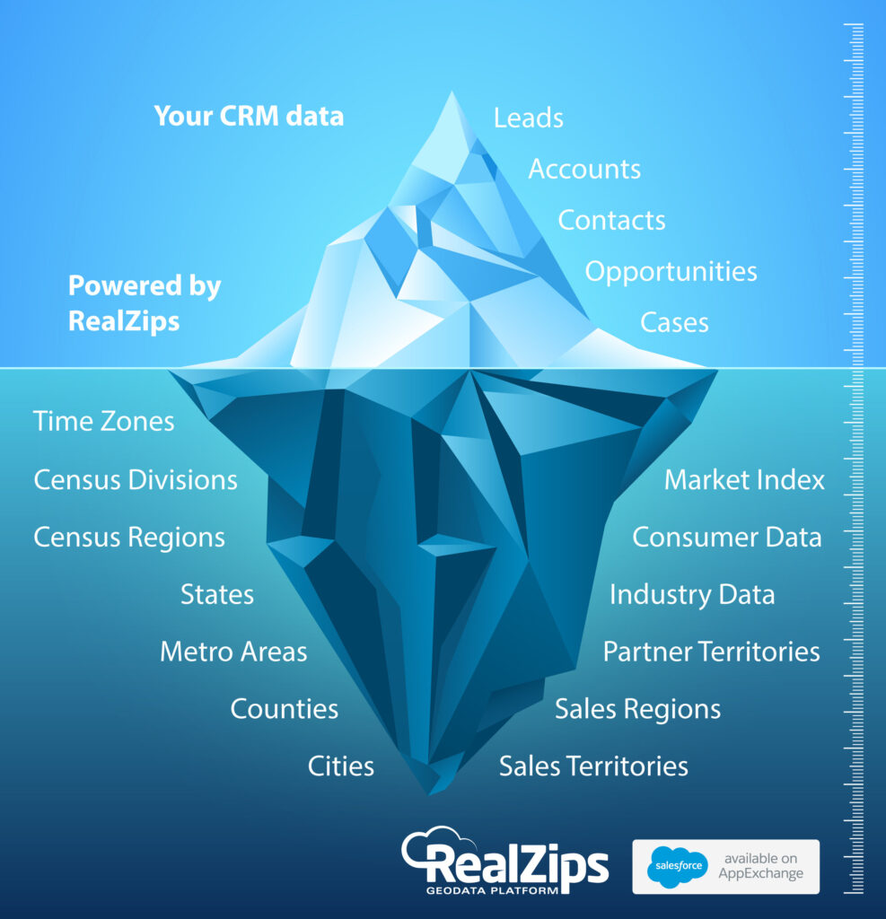
Why Do Organizations Need Zip Code Data?
Source: Why Do Organizations Need Zip Code Data? (Salesforce Blog)
After managing and developing CRM systems for over 25 years, it became clear that organizations are missing out on substantial opportunities to grow revenue. Countless meetings with management, sales, and marketing teams always had the same topics of discussion, which is how to solve the main challenges at hand:
- Our CRM database is growing rapidly and is becoming unstructured.
- We can not effectively run marketing and sales activities across counties, metro areas, or even territories.
- The sales team needs to know exactly where to focus their efforts.
Without geographic data to structure and enhance existing CRM data, and no market data to track against current market share, it’s impossible to effectively manage sales territories for growth. Organizations will therefore continuously ask themselves:
- Are we adding sales reps in geographical areas with too little potential?
- Are we marketing in places where we can generate many new leads?
- What is our market share across zip codes, counties, and metro areas?
And when these questions go unanswered, organizations stand to lose millions of dollars in potential revenue.
Need for Geographic Structure Based on Zip Codes
In order for your organization to know your market potential and effectively track sales performance, a geographic structure for all CRM data should be put in place.
The solution is to add a complete zip code database to your Salesforce organization. Each zip code must hold data points such as city, county, metropolitan area, number of companies and demographics to describe your white space for growth. Each existing CRM record will then automatically link to a zip code, instantly creating 40,000 micro-markets. All market data by Zip code is rolled up into cities, counties, sales territories, and regions, providing your team with unprecedented analytics.
Now, that you have a powerful geographic structure in place, all CRM data is automatically organized by sales region and territories. Leads are instantly routed to the right sales representative. You can adjust ownership across 100,000 contact records in minutes. It’s now possible to give everyone powerful search capabilities, plus powerful geographic drill-down reports and dashboards.
Need for Market Data by Zip Code
There is a tremendous amount of geographic market data available. Market data can display the number of companies by NAICS industry code, or the number of people in a certain job position, targeted by your team.
With regards to consumer targeting, there are endless datasets related to age, income and spending habits. Even if you don’t target consumers directly, almost all companies benefit from knowing the downstream market potential for their sales channels.
To understand market share and growth opportunity, many companies invest in sales data related to competitive products, used to compare against their own sales numbers. However, high-level market share analytics is hard to turn into useful data for the marketing and sales teams across local markets.
With Zip codes in Salesforce, data over competitive performance and your company’s own sales data can be broken down geographically and integrated with existing CRM data. The combined data becomes extremely valuable for marketing and sales. The system can automatically propose the best sales strategy for each Zip code, such as “Avoid – too low potential”, “Maintain – high market share”, and “Grow – few competitors and many leads”.
Combine CRM and Market Data
Next, all data must be automatically combined based on Zip codes. It is now possible to pinpoint each geographic area’s market potential and compare against existing customers.
As soon as your CRM data is integrated with market data, your team can use customer data in completely new ways. For example, territory management becomes a very powerful process, allowing everyone to collaborate in the best target areas.
By adding automated drive time to records in Salesforce, it becomes possible to target leads and customers by these zones. Drive time is an incredibly useful tool for sales reps, service reps, and of course event planners.
With Zip codes in Salesforce, you are giving the field sales team unprecedented insights on where to focus efforts, while they are using Zip code data on the Salesforce1 mobile app.
Improve Marketing and Sales Strategies
Amazing things happen when your team can compare a geographic area’s market potential against existing customers. The moment people can view their growth opportunity in real time, they are very often left speechless. We’re seeing organizations rethink and improve their marketing and sales strategies, as soon as they get their hands on these market insights.
By automatically scoring each Zip code by market potential and sales performance, your marketing and sales teams will have real-time guidance over where to run marketing campaigns and focus sales activities. Your CRM data has now become actionable, and your team will find more customers and close more deals.
How One Organization Thrives on Zip Code Data
A recent client, who sells medical devices to doctors, rolled out our 100% native app, RealZips, to their sales team. This allowed their Salesforce Admin to quickly match their own customer data against competitive sales data.
From there they focused on geographical areas with clusters of leads, picking areas with 10 more leads (10 employees or more), where the competition had over $50,000 in sales. They uncovered over 1,000 new leads in a matter of months and closed 300 new opportunities at an average initial order value of $800. These 300 new customers are expected to generate $2,000 per year in repeat orders.
In short – this organization truly put Zip codes to use – generating an additional yearly revenue of over $500,000.
Accelerate Success
Integrating geographic structure and market data with their existing Salesforce CRM data, organizations can accelerate their revenue growth. The added market data allows your team to proactively focus on geographical areas with the highest growth opportunity.
With Zip codes and market data in Salesforce, you will have a competitive advantage; enabling everyone in your organization to target the right areas, talking to the right customers, at the right time.
7 Steps to Accelerating Revenue with RealZips
Organizations using the Salesforce platform are implementing the RealZips app, empowering their whole team.
Users of RealZips are continuously sharing how they are now closing more deals with our app.
This post shows you the 7 steps successful teams take, as they accelerate their revenue with the app and our market data.
What is the RealZips app?
RealZips adds a geographic structure and market data to all CRM data in Salesforce. Your team will have powerful territory management, thanks to our extensive geographic database based on zip codes. The app and it’s data are 100% native, ensuring no security risks and instant user acceptance.
How will we benefit from RealZips?
The app automatically structures existing CRM data by zip codes, cities, metropolitan areas, counties, sales regions, sales territories and more. The benefits are immediate since your team can search and report customer data in new ways – focusing activities in geographical areas that will generate most sales.
How does the RealZips app work?
RealZips is the world’s only GeoData Platform. This is the quick-take:
- 40,000 zip codes are added to your Salesforce in 15 minutes.
- Zip codes have 50 data points, for geographic structure and market data.
- Existing CRM data records are automatically linked to a zip code.
- Sales territories are based on zip codes, linking all CRM data to sales territories.
What are the steps to get started?
RealZips enables organizations like yours to identify growth opportunities and drive sales results. These are the seven steps organizations take while rolling out the RealZips app:
1. Identify Addressable Market
The RealZips app has very deep market data by zip code, enabling your team to pinpoint the total addressable market. The app describes for example corporate targets across 1,000 industries and ranges of employees, including headquarter locations. The demographics data is incredibly deep, ranging across income, age, and lifestyles.
In RealZips, it’s now possible for organizations to distinguish their total addressable market by their primary market and secondary market.
For example, the primary market for your team might be neurosurgeons, while the secondary market would be patients served by these doctors.
Secondary market data is one of the most powerful ways for sales teams to drive trust in discussions with their prospects.
For example, a rep can showcase the RealZips demographics data for the area surrounding the customer’s office.
2. Set Geographic Structure
The RealZips app structures CRM data dynamically across all geographical level. Your team can instantly use e.g. metropolitan areas and counties, to drive successful marketing and sales activities. New geographic levels can be added on the fly, to include areas for specific marketing campaigns!
With a geographic structure in place, existing CRM data is dramatically enhanced and becomes actionable for both marketing and sales teams. With drive time data in RealZips, a lead can be automatically assigned to the closest sales representative or location. Also, drive time data can be used for marketing campaigns based on all customers’ proximity to your sales representatives or locations.
3. Index Market Potential
Many companies miss out on tremendous growth opportunity – simply by not relating each geographic area, to the local market potential – right in Salesforce.
Without market potential in Salesforce, there is no method to track revenue growth against the total addressable market, optimize territories based and prospects, and empower the sales team across territories.
Marketing teams running campaigns without geographic market potential will not be able to target the best-fit areas, missing out on lead generation and revenue growth.
The RealZips app creates automatic indexes for each zip code. Your team will be able to act on each area’s’ market potential and real-time revenue data.
4. Implement Territory Management
The Territory Management module in RealZips effectively combines each territory’s zip codes, market potential and existing leads, accounts and contacts.
Key metrics for each territory roll up from zip codes, giving the sales team a real-time view over where to find and close deals.
A RealZips Territory can quickly be divided into zones based on drive time for the sales representative.
Sales hotspots can be created on the fly within territories, to manage revenue growth in areas with highest market potential.
As territories are changed – customers can quickly and accurately be reassigned to a new territory – complete with a track record of changes.
5. Focus Marketing Activities
It’s a marketers dream to have all leads and customers organized by MSA Metropolitans, cities, CBSAs, counties, sales territories, and regions. The marketing team can run campaigns in zip codes that can be targeted with Google AdWords campaigns, within a 20-minute drive time of the closest representative or location!
Campaigns can be geared towards areas with the high market potential and no current customers. Events can be launched in the exact areas where most leads and customers can quickly travel to.
6. Empower Sales Teams
Most sales teams struggle to build a pipeline of new customers, and closing deals. The RealZips app is simply designed to empower salespeople to be at the right place, taking to the right customers, at the right time.
RealZips cuts down on the search for new customers, allowing the whole organization to focus on areas with most prospects, as close to as possible to your company’s locations.
7. Accelerate Revenue Growth
RealZips can often be implemented in a matter of days. Our customers love to report back on their sales success. We are seeing motivated organizations drive results within weeks, generating net new revenue streams.
Our app is built on 25+ years of CRM experience within companies producing hyper growth. You can now apply our experience of accelerating sales, by rolling out RealZips and market data to your team.
Ramp up Sales with Drive Time in Salesforce
Help Your Field Sales Team Spend Their Time More Productively
How should selling time be divided between existing customers and new leads? If too little time is spent with existing customers, long-term contracts will be lost. If not enough time is invested in building relations with new leads, not enough new business will be generated.
Catch-22 Paradox
Balancing selling time is a classic Catch-22 paradox; If you take great care of existing customers, it’s hard to find time with new leads. If you only chase new deals, you will lose existing customers.
Balance Sales Time
One method to combat this is simply putting in extra hours — doing more of both farming and hunting — however this is not sustainable. Instead, learn from successful sales professionals who are very effective in how they geographically manage their sales territories.
Avoid the Wild Goose Chase
Over the years, we’ve witnessed how certain sales people focused on a fairly small area of their existing sales territory. They build up relationships with potential customers in their own backyard. On the flip side, we have seen sales reps covering large territories, driving great distances in the process. Can you guess which type of sales professional is capable of building the most sustainable business for themselves?
Lead in Salesforce.com complete with the closest sales rep and service rep, plus approximate Drive Time in minutes:

The Marketing Campaign That Fizzled
We have all seen it before: The marketing team runs a great campaign and creates warm leads for the sales team. The sales team is excited and starts visiting the new leads. But after a few weeks, few of the once-warm leads are getting closer to a close.
Marketing Sending Sales out on Field Trips
Let’s say a marketing campaign generated 20 leads across a sales territory. The sales rep is excited and starts calling the leads and books 5 visits. The first visit turns out to be a 45 minutes drive and the second is a 2.5 hour field trip. The second lead just made our sales person spend almost a whole day of valuable selling time driving instead. From that point, the interest in pursuing more leads usually diminishes significantly.
Run Successful Marketing Campaigns Based on Drive Time
Fortunately, it’s now possible for marketing and sales to coordinate campaigns and lead follow-up in a much better way. By automatically adding the Drive Time between each sales representative and their respective leads in Salesforce, the Marketing team can drastically improve their targeted marketing campaigns.
Salesforce Report with 15,312 Leads Divided by Drive Time Zones
The report below is from Salesforce.com. All leads are automatically put into “Drive Time Zones”. The marketing team intensifies their campaigns in the areas closest to each sales person:

The Benefits of Drive Time Zones in Salesforce.Com Are Compelling:
Marketing can deliver highly targeted leads to the sales team.
Sales can reach more leads and build relations faster.
Customers are better serviced by having their sales rep close by.
Save the Sales Team Thousands of Hours in Drive Time
The people behind the Salesforce app RealZips.com spent years making Drive Time in Salesforce.com possible. Fortunately, your whole team can now take advantage of this new technology within days.
Why zip codes in Salesforce.com?
After developing and managing CRM systems for 25 years, it became clear to us that organizations are missing out on large revenue opportunities.
We had discussions with well over a thousand people in management, marketing and sales and the outcome was always the same:
- Our CRM database is growing rapidly, making it hard to find information.
- Sales can’t manage customers across cities, counties or metropolitan areas.
- We don’t know revenue potential across geographic areas.
Every discussion leads to more unanswered questions:
- How do we know we’re adding sales reps in areas with enough potential?
- Are we spending marketing dollars in areas where we can generate leads?
- Does the economic outlook for an area impact our chances to win deals?
- How much more growth can we capture in local markets?
These unanswered questions cost any company millions of dollars in lost revenue. When marketing and sales spend time and effort in geographical areas with slim growth potential, they are leaving greater opportunities in other locations open for their competition.

Most organizations do not have the right data to find the best areas for revenue growth.
Pinpoint market potential with zip codes
Zip code data have been proven to drive sales success. There’s a tremendous amount of geographic data related to zip codes, that must be used to understand the market potential and track sales performance.
Zip code-based market potential, for example, is the number of companies your team targets, and the number of decision makers to be contacted. Market potential can be demographics data based on age, income, and spending preferences. There are thousands of zip code-based datasets, describing your company’s potential.

Most companies sit on a gold mine of their own market and sales data! But the highly detailed data is unfortunately locked away in invoicing systems and databases that cannot be easily be accessed by marketing and sales teams.
What happens when existing CRM data is structured by zip code?
What if we would put all zip codes into your Salesforce CRM system? Next, we could automatically structure all existing CRM data by Zip code; so all data is highly organized and useful. Every zip code would have the associated city name, county, metropolitan area, number of businesses your team is targeting and many more data points that help describe your true market potential.

Your CRM database will be much more useful when your team can search and report all data by zip code, city, county, sales territory, metropolitan area, sales region, state, census region and much more.
Combine external market potential with your CRM data
When external geographical data – number of decision makers and companies your team should target – is added to each Zip code, many of the original questions are immediately answered. It’s now possible to pinpoint a geographic area’s potential and compare with the number of existing customers.
Salesforce report: Compare the number of potential customers – “Software Publishers” – with existing Leads and Accounts. Review activity level and won opportunities.
The difference between an area’s potential number of customers and the number of existing customers is a true eye-opener. Having instant access to this data changes how companies focus their marketing and sales resources. The data is often used to optimize sales territories and empower the sales team to focus efforts in the right areas and beat sales quotas.
Adding zip code-based sales data to your CRM data
Next type of geographic data to add is your internal data for sold products and services on an aggregated zip code level. The data can be from your own sales, channel sales or from partners.
Drive success by aggregating data by zip code in real-time
It’s a huge upside to automatically combine existing CRM data and zip code based business data.
When adding external data over sales potential with internal sales data, your organization is creating a true competitive advantage.
Zip code-based GeoData is proven to connect you faster with the right customers in the right geographic areas.
Get zip codes and GeoData in Salesforce now; you can’t afford to wait.
Empower Sales with Business Density
How can a sales team plan where to look for growing their business?
Throughout my 20+ years in business development, I’ve been part of mapping out where to find new sales opportunities. It was either my own territory, my team’s territories or a whole company’s regions and territories. The questions are always very similar:
- Where do we have customers today?
- Where can we find new customers?
- How can we find clusters of new customers?
- How do we measure our success?
Business Density Key Metrics
One of the absolutely quickest ways to understand where to look for new customers is the key metric Business Density by zip code, categorized as follows:
- High – 200 or more businesses per square mile
- Medium – Between 30 and 200 businesses per sq. mile
- Low – Less than 30 businesses per sq. mile
This business density metric creates “islands” on a map used to identify general areas where a company should focus their marketing and sales activities. No matter which industry your company specializes in, it provides a powerful guidance for where field teams should engage. Simply start in high density areas and work outwards (see image below).

We have compiled high quality Business Density maps for 30 major markets across the United States.
Empowering sales with RealZips Key Metrics
These key metrics originate from our RealZips app for Salesforce. The RealZips app has many out-of-the-box metrics, which can be combined with your own customer data and sales data. You can add customized data over business density for your industry focus.
Overview of Zip codes and Key Metrics

These key metrics will empower Salesforce.com user in your company, providing guidance to areas where your team can close more deals.
Key Metrics for Zip code 10019 in New York City


